

12 Mountain Trips in Vietnam, from Easy Viewpoints to 3,000 m Treks
The best mountain trip in Vietnam depends on how much time, physical effort and road travel you want. Fansipan and Ba Den Mountain give travelers high viewpoints without a mandatory summit trek. Ha Giang is better for a multi-day mountain road journey, Mu Cang Chai for terraced rice landscapes, and Pu Luong for slower village trekking. Experienced hikers can go much further with Pu Ta Leng, Ky Quan San or Pu Si Lung.
Northern Vietnam contains most of the country’s highest peaks, but a useful mountain itinerary should not be limited to peak climbing. Central Vietnam adds the rainforest trails of Bach Ma, while Da Lat combines LangBiang with pine forest and K’Ho culture. Southern travelers can reach Ba Den Mountain from Ho Chi Minh City in roughly two to three hours by road.
Vietnam changed several provincial boundaries in 2025. This guide uses current administrative provinces while retaining familiar destination names such as Ha Giang and Mu Cang Chai when they help travelers recognize the places they are planning to visit.
Which Mountain Trip in Vietnam Fits Your Travel Style?
| Mountain Destination | Typical Trip | Physical Demand | Best For | Signature Experience |
|---|---|---|---|---|
| Fansipan | Half day by cable car, 1-2 days trekking | Low by cable car, high on foot | First-time mountain travelers | Vietnam’s 3,143 m summit |
| Dong Van Karst Plateau | 3-4 days | Low to moderate walking, demanding roads | Mountain road trips and culture | Ma Pi Leng and Nho Que Canyon |
| Mu Cang Chai | 2-3 days | Moderate | Photography and rice terraces | Golden and water-filled terraces |
| Pu Luong | 2-3 days | Easy to moderate | Village trekking and slow travel | Thai and Muong villages among rice valleys |
| Ta Xua | 2 days, 1 night | Easy to moderate | Cloud hunting | Dinosaur Backbone and highland viewpoints |
| Lao Than | 2 days, 1 night | Moderate to high | First overnight summit trek | Sunrise above Y Ty’s cloud layer |
| LangBiang | Half day to full day | Low to moderate | Da Lat visitors and families | Radar Peak, pine forest and K’Ho culture |
| Bach Ma | Full day or overnight | Moderate | Rainforest hiking and birdlife | Five Lakes, Do Quyen Waterfall and coastal views |
| Ba Den Mountain | Day trip | Low by cable car, high on hiking routes | Southern Vietnam itineraries | Mountain scenery and Buddhist pilgrimage |
| Pu Ta Leng | 2-3 days | High | Experienced trekkers | Primeval forest and rhododendrons |
| Ky Quan San | 2-3 days | High | 3,000 m summit trekking | Long ridgelines and high-mountain forest |
| Pu Si Lung | At least 3 days of trekking | Very high | Experienced expedition trekkers | Remote Vietnam-China border terrain |
For a first mountain holiday in Vietnam, accessibility is usually more important than maximum elevation. Travelers with limited time can combine Sapa and Fansipan, while a longer Northern Vietnam trip can link mountain scenery with village stays, terraced fields and scenic road journeys.
1. Fansipan: Vietnam’s Highest Mountain with Two Very Different Ways Up
- Location: Hoang Lien Son range near Sapa, Lao Cai Province
- Elevation: 3,143 m
- Typical trip length: Half day by cable car; 1-2 days for a guided summit trek
- Best time: April-May and September-October usually offer a better balance of visibility and comfortable conditions
- Best for: First-time visitors, families, photographers and serious trekkers
- Main limitation: Summit cloud, strong wind and maintenance closures can change the experience quickly
Fansipan is the most flexible high-mountain experience in Vietnam because travelers can choose between a cable-car journey and a genuine summit trek. The 3,143 m peak rises above the Hoang Lien Son range near Sapa. A 6.3 km three-rope cable-car system covers the main ascent in about 15 minutes, making high-altitude scenery accessible to people who would never attempt a multi-day climb.

Fansipan reaches 3,143 m, but travelers can experience the summit by cable car or approach it as a serious mountain trek.
The Fansipan cable car ends below the actual summit, so visitors still continue upward by steps or use the summit funicular to reduce the remaining climb. Adult round-trip cable-car tickets are currently around 850,000 VND, but prices and operating schedules change. The system also undergoes scheduled maintenance, so confirm its status before leaving Sapa.
Trekking creates a completely different trip. Forest, elevation gain, wet ground and rapidly changing mountain weather make proper footwear, waterproof layers and a competent local guide more important than the summit photograph. Travelers should also distinguish Fansipan from easier village trekking around Sapa. A Sapa itinerary can combine both, but they require different fitness, clothing and time commitments.
2. Dong Van Karst Plateau: Best for a Mountain Road Journey
- Location: Historic Ha Giang region, now within Tuyen Quang Province
- UNESCO area: 234,500 ha
- Typical trip length: 3-4 days for the classic road circuit
- Best time: Autumn and late spring often provide the most comfortable road conditions
- Best for: Scenic drives, geology, ethnic culture and travelers who do not need to summit a peak
- Main limitation: Hairpin bends, steep drops, fog and changing road conditions demand experienced driving
Dong Van Karst Plateau represents the road-trip side of mountain travel in Vietnam. The UNESCO Global Geopark covers 234,500 ha, contains a geological record extending more than 550 million years and supports 17 ethnic groups. Limestone mountains dominate the landscape, so the experience feels completely different from the forested Hoang Lien Son peaks around Sapa.
The classic route passes Quan Ba, Yen Minh, Dong Van and Meo Vac. Ma Pi Leng is the defining section. The road runs above the Nho Que River and Tu San Canyon, where canyon walls reach roughly 700-800 m in depth. Dong Van and Meo Vac are only about 24 km apart, but repeated viewpoints and narrow mountain roads mean the journey can occupy most of a morning.
Culture is part of the route rather than a separate attraction. The plateau is home to Mong, Lo Lo, Dao, Tay and other communities, while Dong Van Old Quarter and the Vuong Family Palace add architectural context. Travelers can use the existing Ha Giang guide to understand the wider loop before choosing a route.
Foreign visitors should not treat the famous motorbike loop as a casual scooter ride. Travelers without strong mountain-road experience are better served by a local driver or private vehicle. Daylight travel also makes it easier to react to fog, gravel, construction and livestock on the road.
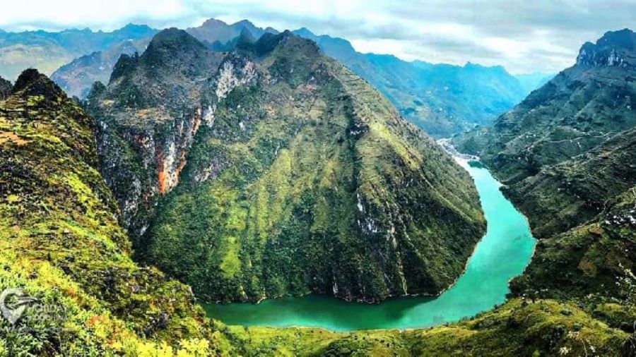
Dong Van Karst Plateau rises boldly in Northeast Vietnam’s geological crown.
3. Mu Cang Chai: Best for Mountain Rice Terraces
- Location: Lao Cai Province, formerly part of Yen Bai Province
- Distance from Hanoi: About 300 km
- Terraced rice area: About 2,200 ha, including around 500 ha recognized as national heritage
- Typical trip length: 2-3 days
- Best time: May-June for water-filled terraces; late September to early October for golden rice
- Best for: Landscape photography, moderate hiking and rural culture
Mu Cang Chai is the strongest choice for travelers who want the mountains themselves to explain how people farm. More than 2,000 ha of rice terraces climb steep slopes around valleys beneath the Hoang Lien Son range. About 500 ha received national heritage recognition in 2007, reflecting the cultural as well as scenic value of the landscape.
The scenery changes dramatically with agricultural timing. During the water-pouring period around May and June, flooded paddies reflect the sky and mountain ridges. By late September and early October, mature rice turns the terraces around La Pan Tan, Che Cu Nha and De Xu Phinh gold. Khau Pha Pass, at more than 1,200 m in elevation, adds one of the region’s major mountain-road viewpoints and hosts paragliding activities during the harvest period.
Mu Cang Chai is about 300 km from Hanoi, but mountain roads make travel time more important than the raw distance. A private vehicle or bus journey commonly consumes much of a day. Travelers who continue deeper into the region should treat Mu Cang Chai as an overnight destination rather than a quick stop.
The terraces are working farmland created and maintained by local Mong communities, not an outdoor photography set. Stay on established paths, do not walk across planted fields without permission, and ask before taking close portraits. The site’s existing Mu Cang Chai guide provides more detail on villages and seasonal landscapes.
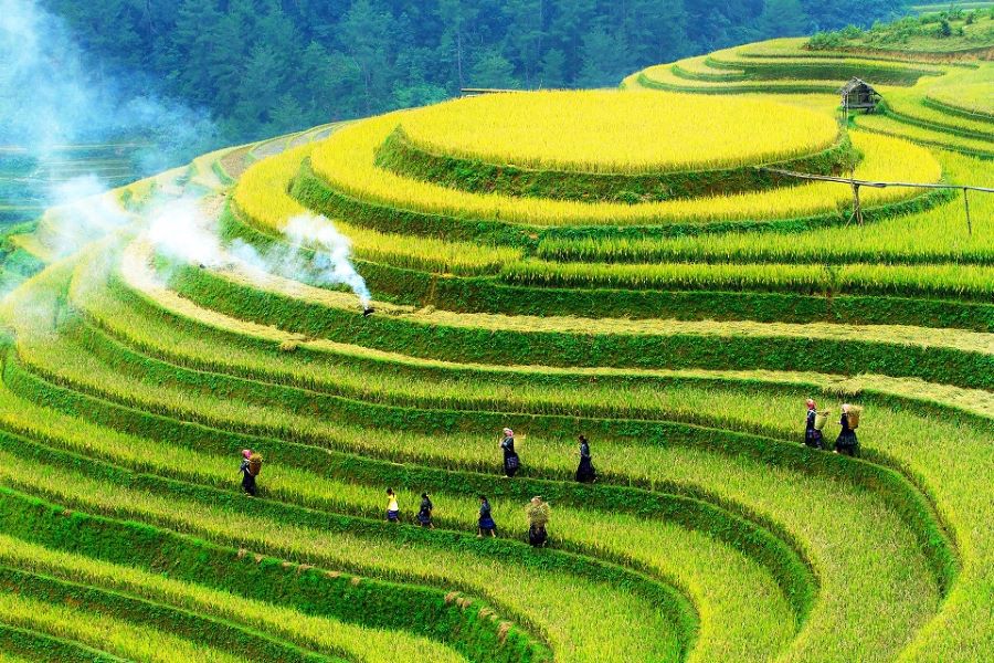
Mist rises gently over Mu Cang Chai’s terraced rice fields at dawn.
4. Pu Luong Nature Reserve: Best for Gentle Village Trekking
- Location: Thanh Hoa Province
- Distance from Hanoi: About 160 km southwest
- Road travel: Around 4.5 hours under normal conditions
- Typical trip length: 2-3 days
- Best time: Late May-early June for green rice; September-October for harvest
- Best for: Couples, families, beginner hikers and slow travel
Pu Luong works best for travelers who want a mountain landscape without organizing a summit expedition. Limestone hills, tropical forest, rice terraces, streams and traditional villages create a softer trekking environment than the high peaks farther north. Thai and Muong communities live throughout the reserve, and village homestays make local daily life part of the route.
Walking paths link rice fields, forest edges and settlements such as Don Village and Hieu Village. Travelers can choose short valley walks or longer hikes without committing to camping above 2,500 m. This makes Pu Luong particularly useful for couples and families whose group members have different fitness levels.
Season changes the landscape. Young rice produces vivid green valleys around late May and early June, while September and October usually bring yellow harvest terraces. Even in hotter months, the combination of limestone hills and tropical forest keeps the reserve cooler than many lowland destinations.
Pu Luong also pairs naturally with Mai Chau or Ninh Binh when designing an overland northern route. The site’s guide to things to do in Pu Luong covers cycling, village stays and other activities that do not require serious mountaineering.

Pu Luong works best for travelers who want a mountain landscape
5. Ta Xua: Best for a Two-Day Cloud-Hunting Trip
- Location: Ta Xua highlands, Son La Province
- Typical tourism elevation: About 1,500-1,800 m
- Distance from Hanoi: About 220 km
- Typical trip length: 2 days, 1 night
- Best time: Roughly September-April for cloud hunting
- Best for: Sunrise photography, road trips and moderate mountain activity
Ta Xua is a cloud-hunting destination rather than a conventional summit-climbing trip for most visitors. The tourism area sits around 1,500-1,800 m and lies roughly 220 km from Hanoi, making a two-day itinerary realistic. Travelers come for early-morning cloud inversions, mountain roads and viewpoints rather than a single marked summit.

Ta Xua’s main travel experience is cloud hunting from highland viewpoints, especially during the cooler months.
Dinosaur Backbone is the area’s best-known ridge, while Dolphin Rock, the Lonely Tree and old Shan Tuyet tea landscapes create additional stops. Cloud formation remains weather-dependent. Even during the stronger September-April window, there is no guarantee of a cloud sea on a particular morning.
Travelers should not confuse this Ta Xua cloud-hunting area with the 2,865 m Ta Xua summit trek associated with the former Tram Tau area. The latter is a demanding multi-day mountain climb with completely different preparation, route and physical requirements. Older articles often merge the two entities, which can leave international travelers dramatically underestimating the summit trek.
Road conditions also deserve respect. Fog can reduce visibility quickly, and wet mountain roads become much more difficult after heavy rain. For a photography-focused visit, staying overnight near the viewpoints is more sensible than attempting the return journey to Hanoi on the same day.
6. Lao Than Mountain: A Manageable Introduction to Overnight Summit Trekking
- Location: Y Ty area, Lao Cai Province
- Commonly published elevation: 2,860 m
- Trail reference: About 9 km to the summit in local tourism material
- Typical trip length: 2 days, 1 night
- Best time: October-March for cooler weather and cloud hunting
- Best for: Fit travelers attempting their first overnight high-mountain trek
Lao Than is a useful bridge between easy mountain sightseeing and Vietnam’s more demanding 3,000 m expeditions. Local tourism sources commonly place the summit at 2,860 m and describe an approximately 9 km ascent. The mountain rises above the Y Ty area, where highland villages and terraced farming give the trek a stronger regional context than a summit-only itinerary.

Lao Than combines an overnight mountain trek with sunrise cloud views above the Y Ty highlands.
The trail crosses open hillside, forest and exposed mountain ground before the summit. Local tourism material estimates roughly four hours for the ascent under favorable conditions, but international travelers should plan more conservatively. Rest stops, weather, photography and fitness can extend the walking time considerably, and most recreational itineraries use an overnight camp or mountain shelter.
Y Ty itself adds cultural value. The area is associated with Ha Nhi communities, distinctive earthen houses and the The Pa terraced landscape. Travelers should ask before entering homes or photographing residents closely. A local guide also reduces navigation risk and helps coordinate food, shelter and porter support on a route where there are few places to buy supplies once the trek starts.
Published elevations for Lao Than are not completely consistent across all planning documents, so this article avoids claiming a national height ranking and uses the 2,860 m figure most commonly published by current Lao Cai tourism sources.
7. LangBiang: Best Mountain Day Trip from Da Lat
- Location: Near Da Lat, Lam Dong Province
- True peak elevation: About 2,167 m
- Vehicle destination: Radar Peak at 1,950 m
- Typical trip length: Half day to full day
- Best for: Families, Da Lat visitors, moderate hikers and cultural travelers
- Main limitation: The tourist vehicle does not reach the true 2,167 m summit
LangBiang gives Da Lat visitors a flexible mountain day because sightseeing and serious hiking do not have to follow the same route. The mountain rises north of the city inside the wider Langbiang Biosphere Reserve, which UNESCO designated in 2015. The reserve covers 275,439 ha and protects 14 tropical ecosystems.
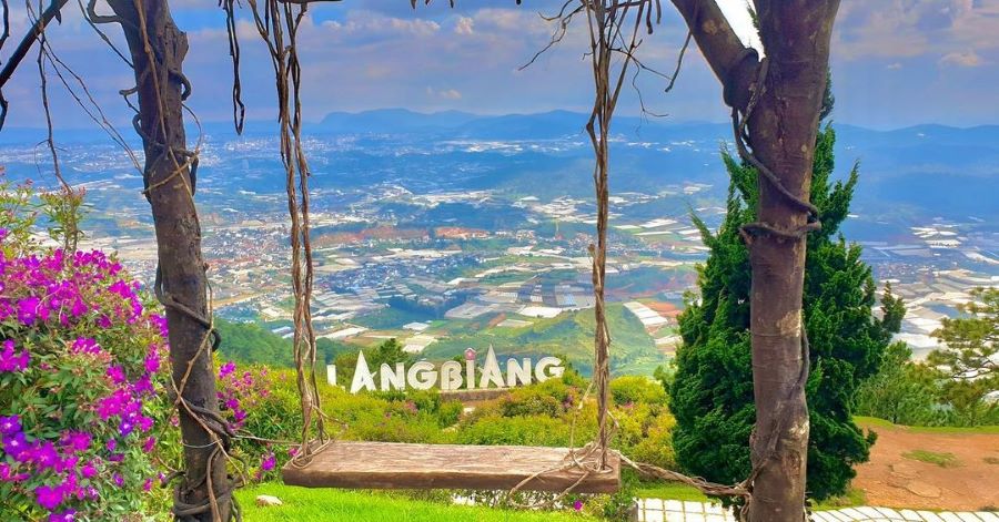
LangBiang combines Da Lat’s cool highland landscape with viewpoints, hiking and K’Ho cultural context.
The commercial visitor area charges an adult entrance fee of approximately 50,000 VND. A specialized vehicle follows about 6 km of mountain road to Radar Peak at 1,950 m, with the ride currently costing about 120,000 VND. This distinction matters because older guides sometimes claim the vehicle reaches LangBiang’s true 2,167 m summit. It does not.
Travelers who want a genuine trek need additional time, proper footwear and a route suited to current trail conditions. Rain can turn forest paths muddy and slippery. Visitors who mainly want a viewpoint can use Radar Peak and save the rest of the day for other places in the Da Lat highlands.
LangBiang also has a cultural relationship with local K’Ho communities. Arabica coffee has been cultivated on these slopes for generations. Visiting a locally run coffee farm or craft producer gives more context than treating K’Ho identity as a costume or photography experience.
8. Bach Ma National Park: Best for Rainforest Mountains in Central Vietnam
- Location: South of Hue, Central Vietnam
- High mountain zone: About 1,450 m
- Typical trip length: Full day or one overnight stay
- Best time: March-September usually gives more favorable hiking weather
- Best for: Rainforest walking, birding, waterfalls and travelers based in Hue or Da Nang
- Current planning issue: Summit-road access has been affected by serious landslide damage
Bach Ma is the most distinctive mountain option in this list for travelers who prefer tropical rainforest to high-altitude trekking. The park lies at the southern end of the northern Truong Son range, where mountains rise close to the coast. Its high zone around 1,450 m is cool enough to create a strong contrast with Hue and the coastal lowlands below.
Classic trails connect Hai Vong Dai viewpoint, Five Lakes and Do Quyen Waterfall. From the high viewpoints, clear weather opens views across Cau Hai Lagoon, Chan May Bay and the coastline. Forest walking also gives Bach Ma a strong biodiversity identity, with hundreds of recorded bird species and a much richer wildlife context than a bare summit trek.
Access requires extra checking before departure. Extreme rainfall in late 2025 caused severe landslides on the road toward the summit, including major damage around km 12. Tourism activity continues in the national park, but travelers should not assume a private car can always reach the traditional high-mountain drop-off point. Confirm the latest road and trail status directly before traveling.
Weather is another constraint. Central Vietnam’s rainy period can bring prolonged rain, landslides and poor trail conditions from roughly October into January. March through September is generally more suitable, but tropical mountain weather can still change during the day.

Bach Ma National Park, home to Five Lakes and Do Quyen Waterfall in southern Hue
9. Ba Den Mountain: Best Accessible Mountain Trip from Southern Vietnam
- Location: Tay Ninh Province
- Elevation: 986 m
- Distance from Ho Chi Minh City: About 100 km
- Road travel: About 2-3 hours depending on traffic
- Typical trip length: Full-day trip or overnight in Tay Ninh
- Best for: Families, older travelers, pilgrimage and visitors based in Ho Chi Minh City
Ba Den Mountain is the most practical substantial mountain experience for travelers whose Vietnam itinerary is centered in the south. The 986 m mountain stands above the flat Tay Ninh landscape about 100 km northwest of central Ho Chi Minh City. Road travel commonly takes two to three hours, making a same-day journey possible.
The Van Son cable-car route covers about 1,847 m and reaches the summit area in roughly eight minutes. A separate Chua Hang line serves the historic Ba Pagoda complex. This distinction allows visitors to choose a scenic summit visit, a pilgrimage route or a combination of both without undertaking the steep hiking routes traditionally used to climb the mountain.
Ba Den is not only a viewpoint. The mountain has a long religious relationship with Linh Son Thanh Mau worship and Buddhist pilgrimage. Visitors entering temples should cover shoulders and knees, lower their voices and avoid standing directly in front of people who are praying. The first lunar month is particularly important for pilgrimage, so crowds can be much heavier than on ordinary weekdays.
Cable-car schedules change by weekday, weekend and weather. Travelers should check Sun World’s current timetable rather than planning around an old fixed opening time. This matters particularly if the mountain is the first or final stop of a long transfer from Ho Chi Minh City.
Advanced Mountain Expeditions in Vietnam
The following three mountains require a different level of planning from Fansipan, Pu Luong or LangBiang. They involve multiple days on foot, basic overnight conditions, local guides or porters and substantial elevation gain. Pu Si Lung also involves border-area procedures. These routes should not be treated as spontaneous additions to a normal sightseeing itinerary.
10. Pu Ta Leng: Primeval Forest and Rhododendron Trekking
- Location: Ta Leng area, Lai Chau Province
- Elevation: 3,049 m
- Distance from Lai Chau: About 20 km northeast
- Typical trip length: 2 days, 1 night to 3 days, 2 nights
- Best time: October-March; rhododendrons are especially notable around March-April
- Best for: Experienced hikers who value forest scenery as much as the summit
Pu Ta Leng stands out because much of the attraction is below the summit. The 3,049 m mountain rises in the Hoang Lien Son range around 20 km northeast of Lai Chau. Routes cross primary forest, streams, waterfalls, moss-covered ground and extensive rhododendron habitat before entering higher, more exposed terrain.
There is no single standard itinerary. Local tourism authorities describe several route combinations. Ho Thau to Si Thau Chai can be completed in about two days and one night, while longer routes toward Ta Leng commonly require three days and two nights. Strong hikers sometimes compress a route, but speed should not replace weather margins and rest.
Rhododendrons give Pu Ta Leng its clearest seasonal identity. Old trees form dense flowering forest above roughly 2,000 m, with the strongest displays often appearing in spring. The combination of flowers and primeval forest makes Pu Ta Leng different from Ky Quan San, where exposed ridges and summit scenery play a larger role.
Si Thau Chai also provides a cultural base. The community sits above 1,400 m and is home to Dao families. Using local guides and porters supports the people who know the water sources, camps and trail variations rather than treating the mountain as an isolated wilderness.
11. Ky Quan San: A 3,046 m Trek from Lai Chau or Lao Cai
- Also known as: Bach Moc Luong Tu in many travel publications
- Elevation: 3,046 m
- Access: Routes can approach from the Lai Chau or Lao Cai side
- Typical trip length: About 2-3 days
- Terrain: Forest, steep rock, streams and exposed ridges
- Best for: Strong trekkers ready for a sustained high-mountain climb
Ky Quan San is better suited to hikers who already know how their body handles full trekking days. The 3,046 m summit sits along the mountainous boundary between the Lai Chau and Lao Cai sides, giving operators more than one approach. Provincial surveys have used routes through Sin Suoi Ho in Lai Chau and the Ky Quan San area on the Lao Cai side.
The trek typically requires two to three days and combines forest walking with steep stone sections, streams and higher exposed ridges. One regional route description puts the total walking distance around 30 km, with long trekking days of roughly seven to eight hours. Actual duration varies considerably with route, weather and group fitness.
The naming can confuse foreign travelers. “Bach Moc Luong Tu” appears widely in Vietnamese tourism content, but Ky Quan San is the locally rooted mountain name and is increasingly used alongside it. Search for both names when comparing route descriptions or communicating with a trekking operator.
Ky Quan San is not simply a harder version of Lao Than. It demands more sustained effort and usually involves a greater commitment to mountain accommodation and porter logistics. Travelers who have never slept on a basic highland trek should start with a less demanding route before building an itinerary around Ky Quan San.
12. Pu Si Lung: Remote Border Trek for Experienced Hikers
- Location: Remote border area of Lai Chau Province
- Elevation: 3,083 m
- Typical mountain section: At least 3 days, 2 nights
- Route length: Provincial tourism sources describe more than 50 km of forest trekking
- Access requirement: Border-area coordination and permission must be arranged in advance
- Best for: Highly experienced trekkers with flexible schedules
Pu Si Lung is the most logistically demanding destination in this list. The 3,083 m peak lies close to the Vietnam-China border in remote Lai Chau terrain. Provincial tourism material describes more than 50 km of forest travel for the mountain route, with steep slopes, river crossings and long distances between support points.

Pu Si Lung requires several days of trekking through remote border terrain and substantially more planning than an ordinary mountain hike.
The trek traditionally starts after coordination with border authorities around Pa Ve Su. This is not a route where an international visitor should arrive independently and expect to complete paperwork on the spot. Foreign travelers should arrange the trip through an experienced local operator that can confirm border, identity and route requirements before departure.
Three days and two nights should be viewed as a minimum mountain commitment rather than the total holiday time. Transfers from Hanoi into western Lai Chau add considerable road travel before and after the trek. Weather disruption can also affect the route, so a tightly scheduled onward flight immediately after the expedition is a poor planning choice.
The old idea that Pu Si Lung is “free if you trek independently after getting a permit” understates both the regulations and practical risks. The real decision is whether your fitness, schedule and logistics justify a remote expedition when Pu Ta Leng or Ky Quan San can provide a 3,000 m trekking experience with less border complexity.
How to Plan a Safe Mountain Trip in Vietnam
- Match the trip to your real fitness: Cable-car summits, village hikes and multi-day 3,000 m treks belong to different physical categories. Do not choose by elevation or photos alone.
- Keep weather flexibility: Northern mountain visibility can disappear in fog, while heavy summer rain increases mud, river flow and landslide risk. Central Vietnam has a later rainy season than much of the north.
- Use local guides on remote routes: Pu Ta Leng, Ky Quan San, Lao Than and Pu Si Lung involve changing trails, water sources and mountain shelters that are easier to manage with local support.
- Avoid inexperienced mountain motorbike riding: Ha Giang, Mu Cang Chai and Ta Xua contain steep bends, fog and exposed roads. A local driver is a safer solution when you are not an experienced rider.
- Carry layers rather than one heavy jacket: Mountain temperatures change between valleys, ridges, daytime sun and early-morning cloud. Waterproof protection matters even when the lowlands are dry.
- Keep some cash: Remote villages, guides, food stops and homestays may not accept international cards. ATMs become less common once you leave regional towns.
- Respect working landscapes: Rice terraces are farms, and mountain villages are homes. Stay on paths, ask before close-up photographs and follow your host’s customs inside houses.
Anyone preparing for the harder routes should test footwear and endurance on shorter hiking trails in Vietnam before committing to several days in remote terrain. Seasonal rain also changes road and trail difficulty, so the country’s rainy-season pattern in Vietnam matters as much as temperature when planning a mountain itinerary.
Plan Your Mountain Journey in Vietnam with Paradise Travel
Paradise Travel is a licensed international tour operator and destination management company based in Hanoi. Established in 2005, the company specializes in private and tailor-made journeys across Vietnam, Laos, Cambodia, Thailand and Myanmar.
Mountain travel in Vietnam often involves more planning than the distance on a map suggests. Weather, road conditions, local guides, trekking permits, overnight camps and long transfers can all affect whether two destinations fit comfortably into the same itinerary. Our Northern Vietnam tours can be tailored around easier mountain landscapes or more active trekking routes. Get in touch with our team if you want help building a realistic route around your travel dates, fitness and preferred pace.

Address: 81 Alley 12 Dao Tan Street, Giang Vo Ward, Hanoi, Vietnam
Hotline: 0989391076
Email: sales@vietnamparadisetravel.com
Frequently Asked Questions

Start planning your tailor-made Southeast Asia tour by contacting one of our specialists…


