

Ha Giang Travel Guide
Ha Giang Overview

Ha Giang is a highland travel region in the northern part of present-day Tuyen Quang Province, corresponding largely to the former Ha Giang Province before the 2025 provincial merger. The region reaches Vietnam’s border with China and combines limestone plateaus, deep river canyons, mountain passes, terraced fields and highland communities. Ha Giang remains the destination name used by travelers, tour operators and tourism authorities even though it is no longer a separate province.
The former Ha Giang Province had more than 910,000 residents and 19 ethnic groups before the merger, with ethnic minority communities accounting for more than 87.7% of the population. This diversity remains especially visible along the northern highlands. Ha Giang 1 Ward, the main gateway for most Loop journeys, has more than 23,000 residents from 18 ethnic groups. Meo Vac Commune has about 20,000 residents from 17 ethnic groups, with Hmong people forming more than 80% of the population.
The demographic pattern becomes even more distinctive toward the Chinese border. Lung Cu Commune has 15,620 residents from 12 ethnic groups, with Hmong people accounting for more than 92%. Elsewhere, Tay, Dao, Nung, Lo Lo, La Chi, Giay and other communities have shaped different settlement patterns, agricultural systems, houses, markets, textiles, food and rituals. Ha Giang should therefore be understood as a cultural landscape as much as a mountain-road destination.
The region is no longer an “untouched” destination. Major Loop viewpoints, Dong Van, Lung Cu and the Nho Que River can become busy during weekends, holidays and flower festivals. What still distinguishes Ha Giang from more resort-developed mountain destinations is the scale of its rural landscape and the close relationship between geology, farming and community life.
Ha Giang Weather and Best Time for Mountain Roads, Rice Fields and Flowers
March-April and September-November offer the strongest overall conditions for a first Ha Giang trip. Spring brings milder weather and flowering trees, while autumn combines more stable mountain travel with golden rice in the west and buckwheat flowers across parts of the rocky plateau.

Weather varies considerably with elevation across Ha Giang’s valleys and high plateaus.
| Travel period | Landscape | Best for | What to expect |
|---|---|---|---|
| January-February | Winter mountains, mist and early spring blossoms | Cultural travel and photography | Cold mornings, fog and occasional frost at higher elevations |
| March-April | Peach, plum and other spring flowers | Loop travel, walking and villages | Generally milder conditions before heavier summer rain |
| May-June | Water-filled terraces in Hoang Su Phi and greener mountains | Rice-field photography and rural landscapes | Warmer weather and increasing rainfall |
| July-August | Very green mountains and active summer agriculture | Flexible trips with backup plans | Highest risk of heavy rain, landslides and road disruption |
| September-October | Golden rice in Hoang Su Phi | Photography, trekking and road travel | One of the strongest periods for western Ha Giang |
| October-November | Buckwheat flowers across parts of the Dong Van plateau | Flower scenery and festivals | Popular weekends can be crowded |
| December | Dry winter landscapes and lingering flower fields in some areas | Quiet road travel | Cold temperatures, fog and shorter daylight hours |
Rice and flower dates change from year to year. In Hoang Su Phi, the water-pouring period generally develops from around May into June, while the strongest golden-rice scenery usually appears in September and early October.
How to Travel from Hanoi to Ha Giang
Ha Giang has no practical passenger railway or commercial airport, so international travelers normally reach the region by road from Hanoi. The journey to the Ha Giang gateway area usually takes about six to seven hours depending on traffic, pickup point and rest stops.
| Travel option | Typical journey | When it works best |
|---|---|---|
| Overnight sleeper or cabin bus | About 6-7 hours | Budget travelers who want to arrive early for the Loop |
| Daytime limousine van | About 6-7 hours | Travelers who prefer a smaller vehicle and daytime journey |
| Private car with driver from Hanoi | About 5.5-7 hours depending on stops | Families, photographers and travelers continuing around Ha Giang by car |
| Motorbike from Hanoi | Substantially longer | Only experienced riders with valid driving documents |
For most travelers, it is better to reach Ha Giang by bus, limousine or car and begin the mountain route after resting. Riding directly from Hanoi adds a long approach before the technically demanding roads of the northern plateau.
The Ha Giang Loop: Route, Duration and Safe Ways to Travel
The Ha Giang Loop is a multi-day mountain-road journey rather than one officially fixed circuit. Most first-time routes connect the Ha Giang gateway with Quan Ba, Yen Minh, Dong Van, Ma Pi Leng, Meo Vac and either Du Gia or another southern return route. Three to four days gives a much better pace than attempting to compress the major stops into two days.

The Ha Giang Loop includes steep mountain passes and requires realistic driving experience and safety planning.
- Easy rider: travel as a passenger with an experienced local motorbike driver. This is the most practical motorbike option if you do not hold valid Vietnamese driving documents or are not experienced on mountain roads.
- Self-drive motorbike: suitable only for experienced riders who hold documents legally valid for the motorcycle category they use in Vietnam.
- Private car with driver: the most comfortable alternative for families, older travelers, photographers and visitors who do not want prolonged motorbike exposure.
Vietnam generally recognizes an International Driving Permit issued under the 1968 Vienna Convention when it is carried together with the corresponding valid national driving licence and covers the correct vehicle category. Other bilateral recognition arrangements exist for some countries, so travelers should verify their exact licence situation before renting a motorcycle.
Motorbike-tour safety is receiving increased official scrutiny in 2026. Tuyen Quang tourism authorities have tightened checks on tour companies, guides, rental businesses, vehicles, insurance and safety procedures after serious accidents involving foreign visitors. Travelers who prefer a professionally arranged route can use Ha Giang tours with a driver and local guide instead of self-driving.
Dong Van Karst Plateau UNESCO Global Geopark: Geology and Highland Heritage
The Dong Van Karst Plateau is the geological core of the classic Ha Giang Loop. Covering about 2,356 square kilometers, it entered the Global Geoparks Network in 2010 and is now one of Vietnam’s UNESCO Global Geoparks.
Dong Van Karst Plateau rises boldly in Northeast Vietnam’s geological crown.
The plateau rises largely above 1,000 meters and preserves limestone, fossils, fault systems and landforms representing hundreds of millions of years of geological history. The same difficult terrain has strongly influenced human settlement: villages occupy small valleys and pockets of cultivable ground, while maize and other crops are grown between exposed limestone formations where conventional large-scale farming is impossible.
The geopark is also a living cultural landscape inhabited by numerous ethnic communities rather than a geological reserve separated from daily life. Hmong, Tay, Dao, Nung, Lo Lo, Giay and other groups maintain markets, religious practices, agricultural traditions and vernacular architecture across the plateau.
In July 2026, UNESCO experts conducted the geopark’s fourth periodic revalidation mission. The assessment examined conservation, education, community participation and sustainable tourism. Until the revalidation process is formally completed, travel content should not assume or announce its result.
Quan Ba, Tham Ma and Sung La: The Scenic Approach to Dong Van
The road north from the Ha Giang gateway introduces the plateau gradually, moving from greener valleys into increasingly exposed limestone terrain.
- Quan Ba Heaven Gate: one of the first major elevated viewpoints on the route, overlooking the Quan Ba valley and surrounding karst landscape.
- Quan Ba Twin Mountains: two symmetrical limestone hills near Tam Son that form one of the area’s most recognizable landscapes.
- Tham Ma Pass: a tightly winding mountain section frequently used as a photography stop, but still an active road where travelers should remain clear of traffic.
- Sung La Valley: a cultivated valley surrounded by limestone peaks, known for seasonal flowers and Hmong settlements.
- Lung Cam Cultural Village: includes the traditional house used as a filming location for the Vietnamese movie The Story of Pao.

The poetic Quan Ba, Ha Giang
Vuong Family Mansion and Dong Van Old Quarter: History on the Rocky Plateau
Vuong Family Mansion in Sa Phin is one of the region’s most important historic buildings. The residence is associated with Vuong Chinh Duc, the influential Hmong leader often known historically as the “Hmong King.” Construction began around 1919 and took nearly a decade, combining Hmong building traditions with Chinese and French architectural influences.
The complex contains courtyards, residential rooms, fortified walls and elaborate carved details. Rather than presenting it only as the home of a wealthy opium trader, the site is more useful for understanding power, trade, architecture and borderland society in the early 20th century.
Dong Van Old Quarter provides a contrasting urban layer. Historic houses cluster around the old market square, while newer hotels, cafes and tourism services have expanded around them. The town is now one of the Loop’s main overnight bases rather than an isolated mountain settlement.
Ma Pi Leng Pass, Nho Que River and Tu San Canyon
Ma Pi Leng, the Nho Que River and Tu San Canyon form one connected landscape and should be planned together rather than treated as three unrelated attractions.
Ma Pi Leng Pass runs for roughly 20 km along the road between Dong Van and Meo Vac. It forms part of the historic Happiness Road, the highland route built through extremely difficult terrain to connect remote northern communities. Official viewpoints along the road provide some of the widest views over the limestone plateau and Nho Que valley.

The winding Ma Pi Leng pass.
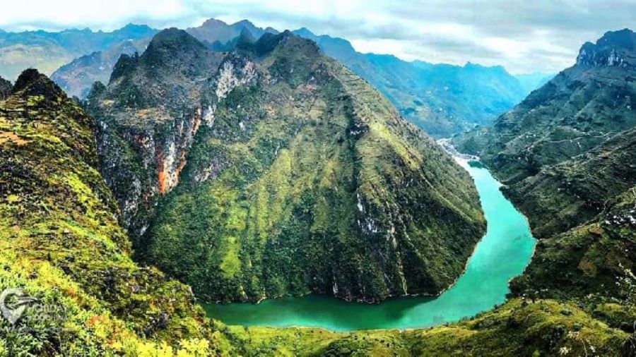
Nho Que River cuts through the limestone landscape below Ma Pi Leng before entering the Tu San gorge. Tourist boats operate through the canyon from the Meo Vac area, although departures depend on water level, visibility and local operating conditions.

Nho Que river, Ha Giang
Tu San Canyon is enclosed by cliffs rising roughly 700-800 meters and extends for about 1.7 km through its best-known section. A boat trip provides a completely different perspective from the Ma Pi Leng road above, with near-vertical limestone walls enclosing the narrow river corridor.
As of August 2026, travelers should not attempt to visit unofficial cliff-edge photo spots that have been closed for safety improvements. The so-called “Death Rock” or “virtual-living rock” area at Ma Pi Leng was closed to visitors from July 1, 2026. Use designated viewpoints and follow local access restrictions.
Lung Cu and Lo Lo Chai: Culture at Vietnam’s Northern Border

Lung Cu Flag Tower is a symbolic northern frontier landmark rather than the exact northernmost geographical point of Vietnam.
Lung Cu Flag Tower stands on Dragon Mountain at about 1,470 meters above sea level. The structure is about 34.85 meters high and flies a 54-square-meter Vietnamese flag symbolizing the country’s 54 officially recognized ethnic groups. The tower is approximately 2 km from Vietnam’s actual northernmost land point, so it should be described as a symbolic frontier landmark rather than the exact geographical extremity.
The surrounding Lung Cu Commune is itself an important demographic entity. It has 15,620 residents across 37 villages, nearly 31 km of international border and 12 ethnic groups, with Hmong people accounting for more than 92% of the population.
Near the tower, Lo Lo Chai provides one of the region’s strongest community-tourism experiences. The village is associated particularly with the Black Lo Lo community, rammed-earth houses, textiles, ancestor traditions and locally managed accommodation. UN Tourism named Lo Lo Chai one of its Best Tourism Villages in 2025, recognizing its work in cultural preservation and sustainable rural tourism.
Living traditions remain active rather than existing only for tourism. The Lo Lo rain-praying ritual and ancestor ceremonies illustrate the relationship between agriculture, spirituality and community life in this borderland environment.
Dong Van and Meo Vac Markets: Highland Trade and Social Life
Weekly markets remain important social institutions across the plateau. They are places for buying livestock, vegetables, clothing and household goods, but also for eating, meeting relatives and maintaining social connections between communities living in dispersed mountain settlements.
Dong Van Sunday Market operates from early morning around the old-quarter market area and brings together traders and families from several ethnic communities. It is busiest in the morning, so staying overnight in Dong Van on Saturday makes more sense than arriving after a long road journey on Sunday afternoon.

Dong Van Old Quarter
Meo Vac Sunday Market is one of the largest highland markets in the region and draws people from surrounding mountain communities. The food area is also a practical place to encounter dishes such as thang co and men men in the context where they remain part of local market culture.
These markets are functioning commercial and social spaces, not costume performances. Ask before taking close-up photographs of individuals and avoid blocking vendors or livestock trading areas for photos.
Ethnic Communities and Cultural Traditions in Ha Giang

Ha Giang’s cultural diversity is expressed through languages, agriculture, architecture, markets and rituals, not only traditional clothing.
Before the 2025 merger, more than 87.7% of the former Ha Giang Province population belonged to ethnic minority communities. Hmong people formed the largest group, followed by substantial Tay, Dao and Nung populations, alongside Lo Lo, La Chi, Giay, Pu Peo and other communities.
- Hmong communities: strongly represented across the Dong Van plateau, where limestone agriculture, maize cultivation, khèn music, earthen houses and highland markets are important cultural attributes.
- Tay communities: more strongly associated with lower valleys, stilt-house settlements and wet-rice agriculture.
- Dao communities: present across several upland areas and known for distinct textile, ritual and agricultural traditions.
- Lo Lo communities: particularly visible around Lung Cu and Meo Vac, with strong ancestor traditions and elaborate textile heritage.
- La Chi communities: closely associated with the western rice-terrace landscape around Hoang Su Phi and Ban Phung.
- Nung communities: contribute to agricultural, market and village life across both eastern and western parts of the region.
Traditional clothing remains an important expression of identity, but travelers should avoid treating ethnic groups as interchangeable “hill tribes” distinguished only by costumes. Language, village organization, farming systems, religious practices and history often differ substantially between neighboring communities.
Hoang Su Phi Rice Terraces: A Separate Western Ha Giang Route

Hoang Su Phi lies west of the classic Dong Van Loop and is best treated as a separate rice-terrace route.
Hoang Su Phi should not be presented as a quick stop on the classic Ha Giang Loop. It lies in the western part of the former Ha Giang region, while the standard Loop heads north and east toward Quan Ba, Dong Van and Meo Vac.
The terraces were recognized as a national scenic heritage site in 2012 and represent generations of agricultural adaptation by La Chi, Dao, Nung, Hmong and other communities. Steep mountainsides were gradually transformed into wet-rice fields through water-management systems adapted to individual valleys and slopes.
- May-June: water-pouring and transplanting period, when terraces can reflect the sky like stepped mirrors.
- September-October: main golden-rice and harvest period.
- Ban Phung: particularly associated with La Chi culture and some of the region’s most dramatic hillside terraces.
- Thong Nguyen and surrounding valleys: useful for trekking, homestays and multi-day countryside routes.
Travelers prioritizing rice terraces should allow additional days rather than trying to combine Hoang Su Phi, Dong Van, Lung Cu and Meo Vac in one rushed three-day circuit. The detailed Hoang Su Phi terraced-field heritage article provides more context on the communities and agricultural landscape.
Festivals and Seasonal Cultural Events in Ha Giang
Festival schedules in the northern highlands often follow lunar dates or annual provincial programs, so exact Gregorian dates should be checked for the year of travel.
- Khau Vai Love Market: held around the 27th day of the third lunar month. The event evolved from a meeting associated with former lovers into a wider cultural festival. In 2026, the main program took place on May 12-13.
- Buckwheat Flower Festival: celebrates the flower closely associated with the Dong Van plateau through cultural performances, local products and tourism activities. The 2026 festival is scheduled to open in Dong Van on November 6.
- Hmong Gau Tao celebrations: spring cultural events involving community ceremonies, music and traditional activities. Timing varies by locality.
- Lo Lo ancestor ceremonies: community rituals remain important in the Lung Cu area and should be approached as cultural and spiritual events rather than staged entertainment.
The festival weekends can produce substantially heavier traffic and accommodation demand in Dong Van, Meo Vac and Lung Cu. Book early if a specific festival is the reason for your trip.
Where to Stay Along the Ha Giang Route
Accommodation should be chosen according to the route rather than by searching for one hotel base for the entire region. Road distances are too long to return to the Ha Giang gateway every night.
- Ha Giang 1 gateway area: best for the night before or after the Loop, bus arrivals and motorbike or car preparation.
- Quan Ba area: useful for a slower first day and travelers who want resort-style accommodation such as H’Mong Village near Trang Kim.
- Dong Van: the most useful northern base for the old quarter, Vuong Family Mansion, Lung Cu and Lo Lo Chai.
- Lo Lo Chai: best for a community-based overnight near Lung Cu rather than conventional hotel facilities.
- Meo Vac: practical for Ma Pi Leng, Nho Que River and the Sunday market.
- Du Gia: suited to a slower rural route and homestay experience on the return side of many Loop itineraries.
- Hoang Su Phi: requires a separate western base when rice terraces and trekking are the main priorities.
Comfort levels vary significantly between hotels, resorts and village homestays. International travelers should check whether a room has a private bathroom, heating or air conditioning, reliable hot water and registered foreign-guest accommodation before booking.
What to Eat in Ha Giang: Corn, Highland Spices and Cold-Weather Dishes
Ha Giang cuisine reflects maize farming, cold mountain weather, local livestock and the culinary traditions of the region’s many ethnic communities. Some dishes are everyday staples, while others are more closely associated with markets or special occasions.

Buckwheat is used for cakes and other foods as well as being grown for its flowers.
- Chao au tau: bitter, warming porridge prepared from properly processed aconite root, rice, broth and meat.
- Thang co: Hmong highland stew traditionally associated with horse meat and offal, although modern versions may use beef, buffalo or pork.
- Men men: steamed cornmeal closely associated with Hmong food culture on the rocky plateau.
- Buckwheat cake: simple cake made from ground buckwheat seeds, commonly sold at markets and flower-season stops.
- Dong Van egg rice rolls: thin steamed rice sheets commonly served with egg and a bowl of hot broth.
- Five-color sticky rice: glutinous rice naturally colored with leaves and plants, associated with several northern ethnic communities.
- Smoked meat: pork or buffalo preserved above the kitchen fire and flavored with northern mountain spices.
- Leaf-fermented corn wine: common highland drink traditionally produced from maize and local fermentation cultures.
Safety note on au tau: the raw aconite root used in this dish is toxic if incorrectly processed. Travelers should eat au tau only as a professionally prepared local dish and should not attempt to prepare the raw ingredient themselves.
Practical Ha Giang Travel Tips for International Visitors
- Do not self-drive without valid documents: most foreign riders relying on an International Driving Permit need a permit recognized by Vietnam together with the matching national driving licence and correct motorcycle category.
- Carry your passport in border areas: Ha Giang contains many communes close to the Chinese border. Foreign visitors may need to show identification, and some restricted border zones require advance permission.
- Check border permits before remote detours: not every standard Loop stop requires a separate permit, but entry into designated restricted or border areas can require prior authorization. The official permit procedure can take up to five working days.
- Respect photography restrictions: do not photograph, film or enter places marked as prohibited near military or international-border areas. Ask locally before operating a drone.
- Refuel before remote sections: fuel stations and repair services become less predictable away from the larger settlements. Fill up before long rural detours.
- Download offline maps: mobile coverage can weaken in deep valleys and remote mountain sections.
- Check road conditions on the same day: heavy rain can cause landslides, falling rocks, temporary closures and roadworks, especially from July through August.
- Use travel insurance appropriate to your activities: regional medical centers operate in the main highland settlements, but serious injuries may require a long road transfer to a larger hospital.
- Wear proper protective equipment: use a certified helmet, closed shoes and weather protection on motorcycle tours even if the operator provides basic equipment.
- Avoid unofficial cliff-edge photo spots: use designated viewpoints and obey closures. The Ma Pi Leng “Death Rock” area remains closed as of August 2026.
- Carry cash: cards are increasingly accepted at larger hotels, but village homestays, markets, small restaurants and entrance points often operate primarily in Vietnamese dong.
- Ask before photographing residents: markets, villages and religious ceremonies are living community spaces rather than photography sets.
Ha Giang Travel FAQ
Is Ha Giang suitable for families with children?
Yes, but a private car with a driver is generally more practical than a multi-day motorbike journey for young children. Choose shorter road days, avoid excessive viewpoint stops and confirm that accommodation has the facilities your family needs.
Can I pay by credit card around the Ha Giang Loop?
Larger hotels and some restaurants accept cards, but cash remains important for homestays, markets, small food shops, fuel and rural services. Withdraw enough Vietnamese dong in larger settlements rather than relying on ATMs in small villages.
Can Ha Giang be combined with Cao Bang?
Yes. Ha Giang and Cao Bang form one of northern Vietnam’s strongest mountain-road combinations, but travel between them requires substantial road time. Allow additional days rather than treating Cao Bang as a quick extension to a 3-day Ha Giang Loop.
How much luggage should I bring on the Ha Giang Loop?
Pack only what you need for several days and leave large suitcases at your gateway hotel when possible. Small bags are easier to manage on motorbikes and in village homestays, where room and storage space can be limited.