

15 Best Trails and Destinations for Hiking in Vietnam 2026
In late 2025, Thanh Hoa Province quietly opened a brand-new official trekking route up Pu Luong Peak – proof that Vietnam’s trekking scene keeps expanding well beyond the familiar names. From Fansipan’s 3,143m summit to a 55km ridge walk across three provinces, Vietnam covers the entire hiking spectrum: gentle rice-terrace walks through ethnic villages, jungle treks past thousand-year-old trees, and multi-day mountain expeditions for experienced climbers. Below are the best trails and destinations for trekking in Vietnam, organized by region so you can match a route to wherever your trip already takes you.
Hiking Trails in Northern Vietnam
1. Fansipan
Fansipan is Vietnam’s classic summit trek and the country’s highest mountain, rising 3,143m above the Hoang Lien Son range near Sapa. The most popular approach starts at Tram Ton Pass and follows a roughly 10.5km mountain route to the summit through forest, bamboo, streams, and increasingly exposed high-altitude terrain. Strong trekkers sometimes complete the climb in one long day, but a 2-day, 1-night trek is a more comfortable choice for most visitors. More demanding alternatives from Sin Chai or Cat Cat are better suited to experienced trekkers. Unlike taking the cable car, trekking Fansipan is a genuine mountain challenge, so good fitness, proper footwear, and an experienced local guide are strongly recommended.
- Location: Hoang Lien National Park, near Sapa, Lao Cai Province
- Type: Mountain trekking / summit trek
- Altitude: 3,143 m
- Distance: Approximately 10.5 km from Tram Ton Pass to the summit (one way)
- Duration: 1-2 days; 2 days 1 night is suitable for most trekkers
- Difficulty: Challenging
- Best time: March-May and September-November; avoid periods of heavy rain and check mountain conditions before departure

Fansipan is Vietnam’s most iconic high-altitude summit trek.
2. Muong Hoa Valley: Y Linh Ho – Lao Chai – Ta Van
Muong Hoa Valley offers one of the best introductions to hiking and village trekking in Sapa. A popular day route descends from the Sapa area through Y Linh Ho, Lao Chai, and Ta Van, following paths between terraced rice fields, mountain streams, and villages inhabited by Hmong and Giay communities. Because different tours start and finish at different points, there is no single fixed distance, but a typical Y Linh Ho – Lao Chai – Ta Van trek covers roughly 9-11km and takes around half a day. Travelers who want a deeper experience can stay overnight in Ta Van and continue the next morning toward Giang Ta Chai and the surrounding bamboo forests.
- Location: Muong Hoa Valley, Sapa, Lao Cai Province
- Type: Village hiking / day trekking
- Distance: Commonly around 9-11 km for the Y Linh Ho – Lao Chai – Ta Van day route; varies by trailhead
- Duration: 4-6 hours for a day hike; 2 days 1 night with a homestay extension
- Difficulty: Easy to Moderate; trails become much more slippery after rain
- Best time: March-May and September-November; late August to early September is especially scenic around the rice harvest
3. Dong Van Karst Plateau and the White Cliffs Walk
For travelers exploring the Ha Giang region on foot rather than only by motorbike, the White Cliffs Walk above Ma Pi Leng Pass is one of the clearest hiking routes to choose. The approximately 5km path connects Xeo Sa Lung with the Ma Pi Leng area, running high above the dramatic limestone gorge and offering sweeping views toward the Nho Que River. The trail is moderately challenging rather than technical, but sections are narrow and exposed, so dry weather and suitable footwear make a significant difference. This hike is best treated as part of a wider Dong Van Karst Plateau journey rather than confused with the famous Ha Giang Loop, which is primarily a road trip.
- Location: Dong Van Karst Plateau UNESCO Global Geopark, Tuyen Quang Province (the former Ha Giang Province)
- Type: Mountain hiking / short trek
- Distance: Approximately 5 km
- Duration: Half day, including scenic stops and transfers
- Difficulty: Moderate
- Best time: October-April for cooler and generally drier conditions; October-November also coincides with the region’s buckwheat-flower season
4. Pu Luong Nature Reserve
Pu Luong combines gentle village hikes with one of northern Vietnam’s newest organized mountain-trekking experiences. Travelers looking for an easier day can walk between Thai villages, rice terraces, waterwheels, and forested valleys, while experienced hikers can tackle the newly developed route to Pu Luong Peak at around 1,700m. The new point-to-point summit route covers approximately 11km from Pu Luong Village to Bang Village and is designed as a 2-day journey. It passes through protected forest, Khoai Cave and Tham Mo Cave before climbing toward the summit, with nearly 2km of the route crossing steep forest slopes of more than 35 degrees. Because marked trails remain limited throughout the reserve, a local guide is strongly recommended.
- Location: Pu Luong Nature Reserve, Thanh Hoa Province, approximately 160 km southwest of Hanoi
- Type: Village hiking and mountain trekking
- Altitude: Approximately 1,700 m at Pu Luong Peak
- Distance: Approximately 11 km for the new Pu Luong Village – Pu Luong Peak – Bang Village route
- Duration: Half-day to full-day for village hikes; 2 days 1 night for the summit route
- Difficulty: Easy to Moderate for valley hikes; Challenging for the summit trek
- Best time: May-early June for green rice terraces and September-October around harvest; always check trail and weather conditions before attempting the summit
5. Cat Ba National Park
Cat Ba National Park is one of northern Vietnam’s most versatile hiking destinations because travelers can choose between a short viewpoint climb and a much longer jungle trek. Near the park headquarters, the Kim Giao Forest – Ngu Lam Peak route takes roughly 1-2 hours and rewards hikers with panoramic views over Cat Ba’s forested limestone landscape. For a more demanding day, the 12km Frog Pond (Ao Ech) – Viet Hai route crosses deeper forest and karst terrain before reaching Viet Hai Village. The national park classifies its shorter routes as walking and hiking experiences and its longer routes as 4-7 hour treks, making Cat Ba suitable for both casual hikers and active travelers.
- Location: Cat Ba Island, Hai Phong City
- Type: Jungle hiking / trekking
- Distance: Short routes around Ngu Lam take 1-2 hours; the Frog Pond – Viet Hai trekking route is approximately 12 km
- Duration: 1-2 hours for Ngu Lam; approximately 4-7 hours for longer forest routes
- Difficulty: Easy to Moderate for shorter hikes; Moderate to Challenging for full-day jungle routes
- Best time: October-April for cooler hiking conditions; avoid long forest routes during heavy rain when limestone and forest paths become slippery
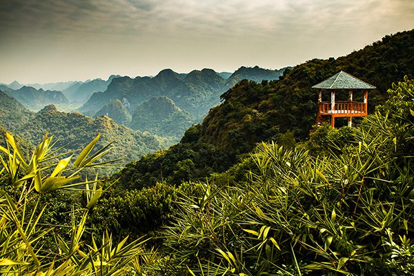
Cat Ba National Park combines short viewpoint hikes with longer jungle treks toward Viet Hai Village.
6. Ba Be National Park
Ba Be is better treated as a trekking destination than simply a place for a boat trip on the lake. Trails cross limestone forest, streams, farmland, and villages belonging to Tay, Dao, and Hmong communities, with options ranging from short walks to full-day jungle routes. One of the stronger day-trek options runs through the park toward Khau Quan and Nam Dai, covering roughly 12-15km and including steep terrain and remote village paths. Easier 5-10km routes can be combined with Ba Be Lake, An Ma Temple, Dau Dang Waterfall, or local villages. For longer and less clearly marked routes, going with a local guide is the safer option.
- Location: Ba Be National Park, Thai Nguyen Province (formerly Bac Kan Province)
- Type: Jungle trekking / village hiking
- Distance: Approximately 5-15 km for common day routes; longer multi-day treks are available
- Duration: Half-day to full-day hikes, or 2-4 days for deeper trekking programs
- Difficulty: Easy to Challenging depending on the route
- Best time: October-April for generally drier hiking conditions; expect wetter and more slippery trails during the summer rainy season
Ba Be combines jungle trekking, ethnic villages and one of Vietnam’s most distinctive freshwater-lake landscapes.
7. Cao Bang: Ban Gioc and Karst Valley Hikes
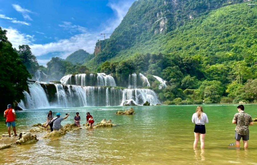
Cao Bang is best presented as a broader hiking destination rather than as a single “Ban Gioc Waterfall Route.” Around Ban Gioc, travelers can follow short walking paths near the falls and climb the hillside to Truc Lam Phat Tich Pagoda for views across the surrounding karst valley. Longer guided hikes venture through limestone valleys, rice fields, ethnic villages, and landscapes around areas such as Phong Nam and Ngoc Con before or after visiting Ban Gioc. This flexible approach makes Cao Bang suitable for travelers who want a scenic half-day walk as well as those looking for a more remote full-day or multi-day trek.
- Location: Cao Bang Province, northeastern Vietnam, near the Vietnam-China border
- Type: Karst-valley hiking / village trekking
- Distance: Varies by route, from short walks around Ban Gioc to longer guided valley and village treks
- Duration: Half-day to full-day hikes; multi-day trekking itineraries are also available across the province
- Difficulty: Easy to Moderate for the Ban Gioc area; Moderate to Challenging on longer remote routes
- Best time: September-November; September usually offers stronger waterfall flow, while October-November brings cooler conditions for hiking

Ban Gioc is the best-known landmark in Cao Bang, but the surrounding karst valleys also reward travelers who explore on foot.
8. Cuc Phuong National Park
Cuc Phuong is one of the most accessible places for genuine jungle hiking in northern Vietnam. Short forest trails lead to ancient trees, limestone caves, and archaeological sites, making the park approachable for first-time hikers and families. More experienced hikers can attempt May Bac, or Silver Cloud Peak, the highest point in the park at 648m. The approximately 6km round-trip route takes around five hours over rugged rainforest terrain and is considerably tougher than the park’s easier visitor trails. With several levels of hiking available in the same protected forest, Cuc Phuong works equally well as a Hanoi or Ninh Binh day trip and as a more active nature experience.
- Location: Cuc Phuong National Park, spanning parts of Ninh Binh, Thanh Hoa and Phu Tho provinces
- Type: Jungle hiking / trekking
- Altitude: 648 m at May Bac (Silver Cloud Peak)
- Distance: Short forest walks vary; approximately 6 km round trip for the May Bac Peak hike
- Duration: 1-3 hours for shorter trails; around 5 hours for May Bac Peak
- Difficulty: Easy to Challenging depending on the trail
- Best time: November-April for generally drier hiking conditions; late April-May is popular for butterfly season, although conditions are warmer and more humid
Hiking Trails in Central Vietnam and the Central Highlands
9. Phong Nha – Ke Bang National Park
Phong Nha – Ke Bang is one of Vietnam’s most versatile destinations for travelers who want to combine jungle trekking with cave exploration. Rather than offering one fixed hiking trail, the national park has experiences ranging from short forest walks to full-day jungle routes and overnight cave expeditions. The Elephant Cave – Ma Da Valley route is a strong choice for a full-day adventure, taking trekkers through tropical forest to caves, streams, and natural swimming areas. More experienced travelers can step up to expeditions such as Hang En, which combines demanding jungle trekking with an overnight camp inside one of the region’s enormous caves. Because many adventure routes enter protected and remote terrain, they are operated as guided trips rather than independent hikes.
- Location: Phong Nha – Ke Bang National Park, Quang Tri Province
- Type: Jungle trekking / cave trekking
- Distance: Varies considerably by route, from short forest walks to full-day and multi-day expeditions
- Duration: Half-day to full-day for lighter routes; 2 days or more for overnight cave treks such as Hang En
- Difficulty: Easy to Challenging depending on the route
- Best time: December-August for many trekking experiences; always check the operating season and weather conditions for the specific cave or trail

10. Bach Ma National Park
Bach Ma National Park is one of the best places for a full day of forest hiking between Hue and Da Nang. After reopening to visitors in January 2026, the park again provides access to its established nature trails around the mountain summit area. From the former Morin villa, an 800m stone path leads to Hai Vong Dai at approximately 1,430m, where hikers can look across mountains, lagoons, and the central Vietnamese coast. From there, visitors can combine forest trails around Ngu Ho, or Five Lakes, with the Do Quyen Waterfall trail. The latter runs about 1.5km from Km 16 of the Bach Ma road before reaching the top of the waterfall, making the summit area easy to build into a half-day or full-day hiking itinerary.
- Location: Bach Ma National Park, Hue City, approximately 40 km south of central Hue
- Type: Forest hiking / waterfall hiking
- Altitude: Approximately 1,430 m at Hai Vong Dai
- Distance: 800 m from the Morin area to Hai Vong Dai; approximately 1.5 km for the Do Quyen Waterfall trail, with longer combinations available
- Duration: Half-day to full-day
- Difficulty: Easy to Moderate, with steeper sections on waterfall trails
- Best time: March-September; check current park and weather conditions before longer hikes
11. Da Lat: Lang Biang and Bidoup – Nui Ba National Park
Da Lat offers both an accessible mountain hike and a much deeper forest-trekking experience. Lang Biang is the easier place to start: a roughly 12km round-trip hike climbs through pine forest, farmland, grassland, and evergreen forest to Nui Ba, the highest peak in the Lang Biang massif at 2,167m. The final section is noticeably steeper, but the established trail has signs and purpose-built sections to help hikers reach the summit. Travelers looking for a longer wilderness experience can continue their exploration in nearby Bidoup – Nui Ba National Park, where the official Bidoup 17km route is designed as a 2-day, 1-night forest trek with camping and ecological interpretation.
- Location: Da Lat and Lac Duong area, Lam Dong Province
- Type: Mountain hiking / forest trekking
- Altitude: 2,167 m at Nui Ba, Lang Biang
- Distance: Approximately 12 km round trip for the Lang Biang summit hike; 17 km for the official Bidoup trekking route
- Duration: Full day for Lang Biang; 2 days 1 night for the Bidoup 17 km route
- Difficulty: Moderate for Lang Biang; Moderate to Challenging for longer Bidoup treks
- Best time: November-April, during the generally drier season in the Da Lat highlands

12. Ta Nang – Phan Dung
Ta Nang – Phan Dung is a true multi-day trek rather than a casual hike and remains one of Vietnam’s best-known long-distance wilderness routes. The full traverse covers approximately 55km, starting in the highlands around Ta Nang and descending through pine forest, open grass ridges, streams, and increasingly dry landscapes toward Phan Dung. Shorter itineraries may cover only selected sections, but completing the full route normally requires several days on foot and at least one night of camping. The combination of long distances, exposed ridges, steep descents, changing weather, and stream crossings makes this a route for fit trekkers rather than beginners. A knowledgeable local guide is strongly recommended, particularly because heavy rain can quickly make streams and slopes dangerous.
- Location: Southern Central Highlands, from the Ta Nang area toward Phan Dung
- Type: Multi-day trekking / long-distance trail
- Distance: Approximately 55 km for the full traverse; shorter itineraries cover selected sections
- Duration: 2-3 days for most guided trekking itineraries
- Difficulty: Challenging
- Best time: Dry-season months are generally preferable; avoid the route during or immediately after heavy rain and always check current weather conditions

Ta Nang – Phan Dung is one of Vietnam’s best-known multi-day trekking routes.
Hiking Trails in Southern Vietnam
13. Cat Tien National Park
Cat Tien is one of southern Vietnam’s best destinations for jungle hiking, particularly for travelers who want wildlife and tropical forest rather than mountain summits. The standout route leads to Bau Sau, or Crocodile Lake, a Ramsar wetland deep inside the national park. From the visitor center, travelers cover the first 9km by park vehicle or bicycle before continuing the final 5km on foot through the forest. The return journey therefore includes about 10km of mandatory walking. The trail itself is not highly technical, but heat, humidity, insects, and the distance make it a more substantial hike than the relatively flat terrain might suggest.
- Location: Cat Tien National Park, Dong Nai and Lam Dong provinces
- Type: Jungle hiking / wildlife trekking
- Distance: Bau Sau is 14 km from the park center; the final 5 km must be walked, making approximately 10 km of forest hiking round trip
- Duration: Around 5 hours for a same-day Bau Sau visit using park transport; longer by bicycle
- Difficulty: Moderate
- Best time: December-April for generally drier forest conditions
14. Ba Den Mountain
At 986m, Ba Den is the highest mountain in southern Vietnam and one of the region’s most demanding short summit hikes. The important difference for hikers today is that access is regulated: the officially approved hiking route from the foot of the mountain to the summit is the Electric Pole Route. Hikers must register their personal information at the management checkpoint before starting and, under current rules, begin their ascent between 5:00am and 11:00am. Visitors should not follow unofficial shortcuts or alternative forest routes, even when they appear on older trekking blogs or GPS tracks, as the mountain management authority has repeatedly warned of accidents and rescues on unauthorized terrain.
- Location: Ba Den Mountain National Tourist Area, Tay Ninh Province
- Type: Mountain hiking / summit hike
- Altitude: 986 m
- Approved route: Electric Pole Route from the foot of the mountain to the summit
- Duration: Allow at least half a day depending on fitness, weather, and trail conditions
- Difficulty: Challenging
- Best time: Dry, stable weather; do not climb during heavy rain, thunderstorms, or strong winds
- Important: Registration is required before hiking, and current regulations permit departures from 5:00am to 11:00am
15. Con Dao National Park
Con Dao adds a completely different hiking landscape to this list: tropical rainforest, coastal forest, isolated bays, and island viewpoints rather than inland mountains. The national park operates several official hiking routes, making it easy to choose a trail based on available time. So Ray is a manageable half-day forest hike to a former plantation and viewpoint roughly 260m above sea level, while Dam Tre Bay is a more adventurous full-day option combining forest trekking with a remote coastal ecosystem. The national park estimates 6-8 hours or more for the Dam Tre experience and requires visitors to go with a park guide. Because some coastal approaches are affected by weather and sea conditions, hikers should confirm current access before setting out.
- Location: Con Dao National Park, Con Dao Special Zone, Ho Chi Minh City
- Type: Rainforest hiking / coastal trekking
- Main routes: So Ray for a half-day hike; Dam Tre Bay for a full-day trek
- Duration: Half-day for So Ray; approximately 6-8 hours or more for Dam Tre Bay
- Difficulty: Easy to Moderate for shorter forest hikes; Moderate for longer coastal routes
- Best time: November-April for generally drier hiking conditions; March-April can combine relatively dry trails with favorable island weather
- Important: A Con Dao National Park guide is required for the Dam Tre Bay trekking route; check current weather and access conditions before departure
Essentials for Trekking in Vietnam
1. Hiking shoes
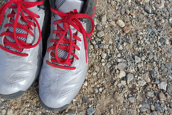
A pair of hiking shoes
Shoes are one of the most important items you need to choose, and this is also a personal option. Some trekkers prefer ankle-high boots, while others prefer lightweight terrain running shoes. The terrain you will be walking may also affect your decision. Light, low-necked shoes work well on roads that are not too rugged, without many obstacles, while boots serve you better on dirt roads, roots, and stream crossings.
Whichever type you choose, make sure your shoes or boots are properly broken in and comfortable for walking long distances. Wear wool or synthetic socks rather than cotton.
2. Trekking clothes
Choose clothes made of quick-drying, moisture-wicking fabric, such as wool or polyester. Avoid cotton because it takes longer to dry when wet.
- Base layer: wool or polyester, most important for cool to cold temperatures.
- Hiking layer: nylon and/or polyester pants, a T-shirt, sunscreen, a sun hat.
- Insulation: a light fleece, warm hat, and gloves, depending on altitude and season.
- Rain layer: a waterproof jacket regardless of the forecast; rain pants if wet weather is likely.
3. Trekking backpack
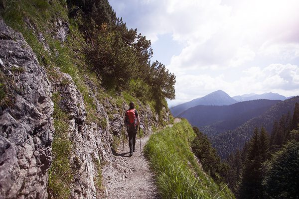
Carry all your things in a backpack and go!
For short trips on well-maintained trails with good weather, a 15-20 liter backpack provides enough space for water, snacks, and a light layer. For multi-day treks like Ta Nang – Phan Dung or Ta Lien Son, a 30-liter pack is a better fit for the additional food, water, and clothing you’ll need.
4. Food & water
As a general guide, plan for 200-300 calories per hour and about half a liter of water per hour in moderate conditions – more in heat or at altitude. On multi-day treks with reliable streams (Pu Luong, Ta Lien Son), a water filter or purification tablets reduce how much you need to carry.
5. Personal health & safety
- Carry a first aid kit and know basic first aid, especially on remote multi-day routes.
- Pack out all waste, including on well-trafficked trails like Fansipan and Cat Ba.
- On remote routes like Ta Lien Son, Apachai, or the En Cave trek, a Personal Locator Beacon (PLB) is worth considering, and always hire a local guide.

Prepare first aid kit to protect yourself and help your partners in case of injury
Trekking Etiquette and Nature Rules
- Plan ahead and check trail conditions before you go, especially in the rainy season.
- Uphill hikers have the right of way; step aside on flat sections to let them pass.
- Stay on the marked trail rather than cutting shortcuts or widening the path around mud.
- Pack out all trash, including food scraps.
- Keep dogs leashed, and yield to horses and bikes on shared trails.
- Respect wildlife and other trekkers; keep noise and music (headphones only) to a minimum.
See more: Essential International Travel Etiquette Tips For Every Tourist
Plan Your Vietnam Trekking Trip with Paradise Travel
Paradise Travel is a licensed international tour operator headquartered in Hanoi, operating across Vietnam, Laos, Cambodia, Myanmar, and Thailand since the early 2000s, and holds the TripAdvisor Travelers’ Choice Award for 2018, 2019, and 2024.
From arranging a licensed local guide and porters for a multi-day route like Ta Nang – Phan Dung, to building a lighter Sapa village walk into your North Vietnam tour, our local consultants can match a trek to your fitness level, timeframe, and the rest of your itinerary. Get in touch with our team to start planning.

Address: 81 Alley 12 Dao Tan Street, Giang Vo Ward, Hanoi, Vietnam
Hotline: 0989391076
Email: sales@vietnamparadisetravel.com
Frequently Asked Questions

Start planning your tailor-made Southeast Asia tour by contacting one of our specialists…


