

Hoang Su Phi Terraced Rice Fields – Vietnam’s Hidden Gem
Carved into the towering slopes of the Song Chay mountain range in northern Vietnam, the terraced rice fields of Hoang Su Phi represent one of the most astonishing agricultural and cultural wonders in Southeast Asia. Unlike the heavily visited valleys of Sapa or the manicured passes of Mu Cang Chai, Hoang Su Phi remains a raw, wild, and deeply authentic highland frontier. Over centuries, generations of twelve ethnic minority communities, including the La Chi, Red Dao, Nung, Tay, and Hmong, have sculpted more than 3,700 hectares of near-vertical mountain slopes into stepped stairways of survival, spirituality, and breathtaking natural beauty.
Officially recognized as a National Landscape Monument in 2012, this dramatic region transforms through distinct agricultural seasons. In late spring, mountain streams fill the terraces to create thousands of shimmering water mirrors during the water pouring season. By early autumn, these same slopes erupt into a cascading sea of glowing golden rice. Whether you are an adventurous trekker seeking remote mountain trails, a photographer hunting cloud-draped sunrise reflections, or a cultural traveler eager to experience authentic ethnic homestays, this comprehensive 2026 guide covers everything: the six core heritage communes, seasonal timing, trekking trails, practical road logistics, and essential etiquette.

Stunning terraced rice fields covered in clouds in Hoang Su Phi
Geographical Setting and Cultural Heritage of Hoang Su Phi
Hoang Su Phi is situated in the rugged western highlands of northern Vietnam, roughly 300 kilometers northwest of Hanoi and 80 kilometers west of Ha Giang center. The region is defined by the steep southern and eastern flanks of Mount Tay Con Linh, the highest peak in northeastern Vietnam at 2,427 meters, and the deep, fast-flowing gorges of the upper Chay River basin.
Note: Following the administrative restructuring in late 2025 and the consolidation of regional boundaries connecting Ha Giang and Tuyen Quang, local governance was reorganized into smaller administrative commune units. Throughout this guide, we refer to the historical and internationally recognized geographical area of the former Hoang Su Phi District, which encompasses the six core national heritage terraced communes celebrated among global travelers and photographers.
What sets Hoang Su Phi apart from other famous terraced rice fields in Northern Vietnam is its sheer verticality and architectural ingenuity. While valleys elsewhere feature broader, gentler tiers, the terraces of Hoang Su Phi cling to mountain gradients ranging from 30 to over 60 degrees. Due to the high altitude and local microclimate, farmers here produce only one single rice harvest per year, relying entirely on natural rainwater and intricate bamboo aqueducts to channel stream water from virgin mountain peaks. This delicate relationship between geography, climate, and human ingenuity has preserved an agrarian lifestyle largely unchanged for generations.
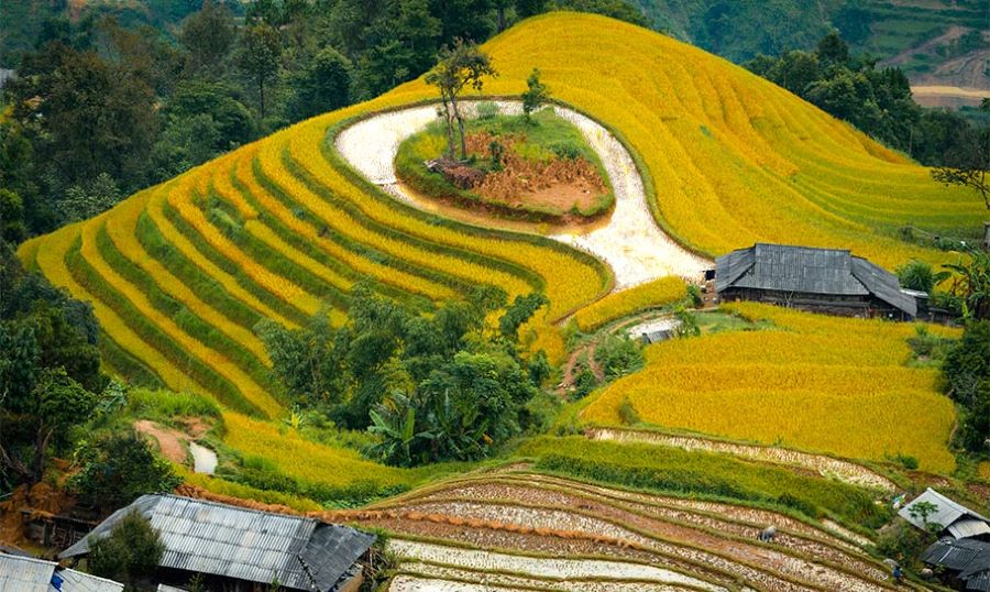
Hoang Su Phi paints horizons with rice fields glowing at autumn sunrise.
Top 6 Terraced Communes in Hoang Su Phi
The National Heritage designation encompasses terraced fields across multiple distinct communes. Each commune possesses its own unique topography, altitude, ethnic traditions, and visual character. The master comparison table below summarizes the six premier terraced areas to help you plan your trekking routes and photography stops.
| Commune / Area | Primary Ethnic Group | Average Altitude | Terrace Characteristics | Best For |
|---|---|---|---|---|
| Ban Phung | La Chi | 1,200m to 1,400m | Highest, steepest cliffside terraces in Vietnam; deep drop-offs | Sunrise cloud inversions, dramatic photography, La Chi culture |
| Thong Nguyen (Nam Hong) | Red Dao | 600m to 900m | Lush layered terraces at the confluence of three grand mountain streams | Trekking hub, upscale eco-lodges, herbal baths, tea hills |
| Ban Luoc & San Sa Ho | Tay, Nung, Dao | 800m to 1,000m | Largest continuous terrace acreage; soft crescent-moon curves | Expansive panoramic views, leisurely village walks |
| Ho Thau | Red Dao | 900m to 1,150m | High-altitude terraces interwoven with natural primary forest | Forest-terrace contrast, wilderness trekking, Chieu Lau Thi ascent |
| Nam Ty | Red Dao, Nung | 700m to 900m | Cascading layers along mountain ridges parallel to route DT177 | Roadside vistas, convenient photography stops |
| Ta Su Choong & Ban May | Hmong, La Chi | 1,000m to 1,300m | Remote terraced valleys hidden behind ancient Shan Tuyet tea forests | Off-the-beaten-path trekking, ancient burial stone mounds |
Detailed Profiles of the 6 Heritage Terraced Communes
1. Ban Phung: The Dramatic Sky-High Terraces of the La Chi
Perched high in the northwestern corner of the district near the Chinese border, approximately 30 kilometers from old Vinh Quang town, Ban Phung is universally celebrated as having the highest and steepest terraced rice fields in Vietnam. Built into the near-vertical flanks of towering limestone and granite mountains, the terraces of Ban Phung plunge hundreds of meters down into the deep valley of the Chay River.
Ban Phung is the historic heartland of the La Chi ethnic group, who have inhabited these remote heights for centuries. La Chi stilt houses, constructed with wooden frames and earthen basements, sit clustered on rocky outcrops directly above the rice fields. In the early morning, thick mountain mists rise from the river valley below, creating surreal cloud inversions where stilt houses and terraced steps appear to float on an ocean of white clouds.
Altitude: 1,200 to 1,400 meters above sea level
Best Photography Time: Dawn (05:30 to 07:00) from the upper viewpoint road looking east over the cascading valley
Access Route: Concrete mountain road branching from provincial route DT177 (accessible by private car or motorbike; narrow with steep hairpin bends)
Highlight: Mystical La Chi stilt houses perched above endless vertical terraces.
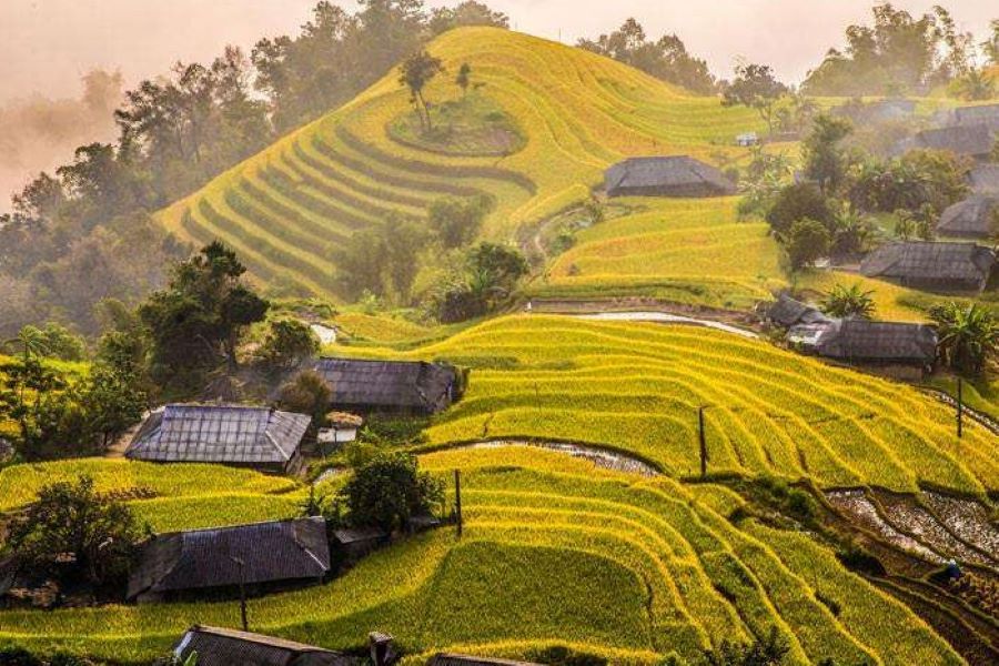
Ban Phung – Phung Village in Hoang Su Phi glows with endless golden rice terraces.
2. Thong Nguyen and Nam Hong: The Cultural and Eco-Trekking Center
Located on the southeastern gateway of Hoang Su Phi where three mountain streams(Phin Ho, Nam Ong, and Nam Khoa) converge, Thong Nguyen is the most accessible and versatile commune in the region. Unlike the sheer vertical drops of Ban Phung, the terraces of Thong Nguyen and its upland village of Nam Hong roll across gentler slopes, creating expansive amphitheatres of emerald and gold surrounded by crystal-clear streams and ancient bamboo groves.
Nam Hong village is home to a thriving Red Dao community known for their elaborate indigo clothing, silver jewelry, and traditional botanical medicine. Visitors can experience the famous Red Dao medicinal herbal bath, prepared by boiling dozens of freshly gathered wild forest leaves in large cedar tubs. Thong Nguyen also hosts the premier eco-lodges of the region, making it the ideal base for guided hiking excursions and day treks into neighboring traditional craft villages in Vietnam.
Altitude: 600 to 900 meters above sea level
Best Photography Time: Late afternoon (15:30 to 17:30) when warm golden light illuminates the river valley
Access Route: Located directly along route DT177, roughly 40 km from Tan Quang junction
Highlight: Red Dao community tourism, mineral herbal baths, century-old Shan Tuyet tea trees, comfortable eco-lodges
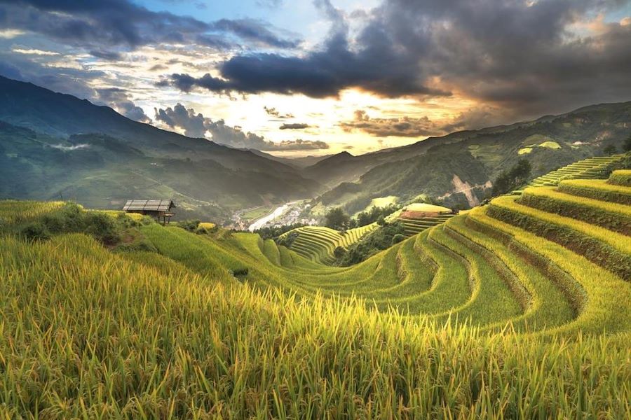
Hoang Su Phi treasures Thong Nguyen, a peaceful land of golden harvest.
3. Ban Luoc and San Sa Ho: Vast Crescent-Moon Terraces
Nestled along the central slopes of the mountain range near old Vinh Quang town, the adjoining communes of Ban Luoc and San Sa Ho boast the largest contiguous surface area of terraced rice fields in Hoang Su Phi. Carved predominantly into fertile earthen hills rather than rocky cliffs, the terraces here curve gracefully in sweeping, crescent-moon arcs that follow the natural contours of the mountain.
Inhabited mainly by the Tay, Dao, and Nung communities, Ban Luoc offers tranquil walking trails that meander directly through terraced valleys, connecting peaceful hamlets of traditional wooden stilt houses. The vast expanse of these terraces makes Ban Luoc one of the finest locations in northern Vietnam for wide-angle landscape photography, especially when sunlight casts layered shadows across the curved earthen ridges.
Altitude: 800 to 1,000 meters above sea level
Best Photography Time: Mid-morning (08:00 to 10:30) and golden hour sunset (16:30 to 18:00)
Access Route: Short 5 to 10 km drive from old Vinh Quang town center
Highlight: Expansive sweeping curves, authentic Tay and Nung stilt house hamlets, peaceful valley walks

In Hoang Su Phi, Ban Luoc sparkles under morning sun on rice terraces.
4. Ho Thau: Terraces Interwoven with Ancient Primary Forests
Situated on the high western ridges of Hoang Su Phi on the lower slopes of Chieu Lau Thi mountain, Ho Thau presents a distinct landscape where agricultural fields merge seamlessly with dense, mossy primary forests. To prevent soil erosion on the steep gradients, Red Dao ancestors intentionally left wide belts of virgin forest between terraced clusters.
This unique architectural layout creates an exceptional visual contrast between dark green evergreen canopies and glowing yellow or water-filled rice paddies. The terraced fields in Ho Thau are remarkably tall and steep, requiring stone-lined earthen borders meticulously maintained by local families. Ho Thau also serves as the primary base for trekking expeditions ascending to the 2,402-meter summit of Chieu Lau Thi.
Altitude: 900 to 1,150 meters above sea level
Best Photography Time: Early morning as mountain mist filters through the forest canopy onto the rice steps
Access Route: Approximately 16 km west of old Vinh Quang town along concrete mountain roads
Highlight: Forest-bordered terraces, Red Dao cultural traditions, gateway to Chieu Lau Thi peak

Hoang Su Phi embraces Ho Thau, where rice terraces sparkle at dawn.
5. Nam Ty: Layered Ridge Terraces Along Route DT177
Stretching along the central mountain spine of Hoang Su Phi, Nam Ty is one of the most prominent National Heritage sites visible directly from the main transportation artery of route DT177. The terraces here descend from high mountain ridges down toward the river canyon in dozens of perfectly parallel tiers.
Because the road winds directly along the crest of the mountain, travelers driving or riding through Nam Ty enjoy continuous, unobstructed panoramic viewpoints without needing to hike deep into remote valleys. The terraced slopes are dotted with Red Dao and Nung settlements, surrounded by ancient Shan Tuyet tea plantations that produce some of the most prized organic green tea in northern Vietnam.
Altitude: 700 to 900 meters above sea level
Best Photography Time: Midday to late afternoon for dramatic shadow play across deep valley tiers
Access Route: Located directly along provincial road DT177
Highlight: Effortless roadside photography, expansive panoramic valley depth, organic Shan Tuyet tea gardens

Nam Ty in Hoang Su Phi glistens with endless golden terraced rice fields.
6. Ta Su Choong and Ban May: Off-the-Beaten-Track Serenity
For adventurous travelers seeking complete seclusion away from any tourism footprint, Ta Su Choong and Ban May in the southern and western valleys offer an untouched glimpse into traditional mountain life. These remote communes feature terraced fields sculpted around rushing waterfalls, giant granite boulders, and ancient La Chi burial mounds.
The trek between Ta Su Choong and neighboring hamlets takes hikers along centuries-old footpaths used by Hmong and La Chi villagers to herd water buffaloes and transport rice crops. The atmosphere here is deeply peaceful, with zero commercial development, allowing visitors to experience the pristine rhythm of highland agricultural life.
Altitude: 1,000 to 1,300 meters above sea level
Best Photography Time: Sunrise and morning mist rising from forest ravines
Access Route: Rough secondary mountain trails branching south from old Vinh Quang (recommended with local guides only)
Highlight: Pure wilderness solitude, cascading waterfalls, ancient La Chi heritage sites

The stunning terraced rice fields of Ta Su Choong in Ha Giang, Vietnam.
Best season to visit Hoang Su Phi
We mostly visit Hoang Su Phi for sightseeing and trekking amidst the terraced rice fields; therefore, the best time of year to go is during the rice-ripening season. The golden harvest season is the most famous and visually spectacular period in Hoang Su Phi. By mid-September, the endless terraces across Ban Phung, Nam Ty, and Thong Nguyen ripen into brilliant shades of amber, gold, and bronze. The air is filled with the sweet, soothing fragrance of ripe rice.
During these four to five weeks, entire villages mobilize for the harvest. Families cut the stalks by hand with small sickles, thresh the grain directly on wooden tubs in the fields, and carry heavy woven bamboo baskets of golden rice up steep mountain trails to traditional stilt granaries. The annual Hoang Su Phi Terraced Fields Cultural Week, held in late September, features traditional sports, folk performances, and paragliding shows over the golden valleys.
However, even if you miss the golden rice harvest season, the other seasons offer a beauty that is no less distinctive amidst the majestic landscapes of Hoang Su Phi.
| Season | Months | Landscape & Visual Appearance | Farming Activities | Travel Experience |
|---|---|---|---|---|
| Water Pouring Season | May to June | Shimmering water mirrors; vibrant reflections of sky, clouds, and mountain peaks | Channeling stream water, buffalo plowing, transplanting green rice seedlings | Photographer’s dream; active cultural observation of farming life; moderate crowds |
| Lush Green Season | July to August | Vibrant emerald green carpet coating the entire mountain slopes | Weeding, fertilizing, caring for growing rice plants; lush mountain vegetation | Peaceful and cool; minimal tourists; ideal for quiet hiking and trekking |
| Golden Harvest Season | Mid-September to Mid-October | Endless golden yellow waves; warm autumn sunlight; sweet aroma of ripe grain | Harvesting by hand, threshing rice in fields, carrying bundles to granaries | Peak travel season; vibrant festival atmosphere; booking accommodation early is vital |
| Winter & Spring Awakening | November to April | Earthy brown terraces; pink peach blossoms; white plum flowers; sea of clouds | Resting soil, planting buckwheat and winter vegetables, harvesting tea leaves | Cloud hunting on Chieu Lau Thi, cultural spring festivals, crisp mountain air |

Terraced rice fields reflecting the sky during the water season in northern Vietnam.
Trekking among the terraces in Hoang Su Phi
Trekking is by far the most rewarding way to experience Hoang Su Phi. Walking along narrow terrace dikes, crossing bamboo suspension bridges, and climbing ridgeline footpaths allows travelers to reach untouched hamlets that vehicles cannot access.
Route 1: The Cultural Eco-Loop (2 Days / 1 Night)
Itinerary: Thong Nguyen – Nam Hong – Nam Khoa – Thong Nguyen
Difficulty: Moderate (4 to 5 hours of walking per day)
Highlights: Starting from Thong Nguyen, trek through verdant tea plantations and primary bamboo forests up to Nam Hong village. Stay overnight at a community homestay or eco-lodge, enjoy a Red Dao herbal bath, and continue the following day across the terraced valleys of Nam Khoa before descending back to the river.
Route 2: The Grand Heritage Traverse (3 Days / 2 Nights)
Itinerary: Thong Nguyen – Ho Thau – Ban Luoc – Ban Phung
Difficulty: Active / Challenging (5 to 7 hours of walking per day)
Highlights: A premier cross-mountain expedition traversing four distinct heritage communes. Cross the forested ridges of Ho Thau, descend into the vast crescent terraces of Ban Luoc, and conclude with the dramatic vertical cliffs of Ban Phung. This route is a highlight of customized North Vietnam tours and requires a knowledgeable local guide.
Attractions Beyond the Rice Terraces
While the terraced rice fields remain the primary reason to visit Hoang Su Phi, the region also offers remarkable natural summits and cultural landmarks that can be seamlessly incorporated into your itinerary.
| Attraction | Type | Location | Highlights |
|---|---|---|---|
| Chieu Lau Thi Peak | Mountain Summit (2,402m) | Ho Thau Commune | Second highest peak in Ha Giang; famous for spectacular sunrise cloud hunting and ancient dwarf rhododendron forests |
| Tay Con Linh Peak | Mountain Summit (2,427m) | Spanning Hoang Su Phi & Vi Xuyen | Highest mountain in northeastern Vietnam; sacred to the La Chi; dense mossy primeval jungle and wild tea forests |
| Suoi Thau Grassland | Highland Meadow | Xin Man District (Neighboring) | Rolling green alpine meadows dubbed “Little Switzerland,” framed by pine trees, buckwheat fields, and wooden stilt homes |
| Hoang Su Phi Sunday Market | Ethnic Cultural Fair | Vinh Quang Town | Vibrant weekly fair where Dao, Hmong, Tay, and Nung gather before dawn to trade cattle, agricultural tools, fabrics, and forest honey |
| Ancient La Chi Tombs | Historical Site | Ban Phung & Ban May | Mysterious centuries-old giant earthen burial mounds tied to sacred La Chi founding legends and ancestor worship |
How to Get to Hoang Su Phi from Hanoi
Located roughly 300 kilometers northwest of central Hanoi, reaching Hoang Su Phi requires navigating winding mountain roads. The journey takes between 6.5 and 8 hours depending on your chosen transport mode.
Option 1: Private Car with Driver (Most Recommended)
Booking a private vehicle provides the greatest comfort, safety, and flexibility. The route follows the modern Noi Bai – Lao Cai Expressway or Noi Bai – Tuyen Quang Expressway to Tuyen Quang City, continuing along National Highway 2 to Tan Quang junction (Bac Quang), before ascending provincial road DT177 into Hoang Su Phi. Arranging a reliable Vietnam car rental with driver ensures safe navigation on mountain passes while allowing spontaneous photo stops.
Option 2: Overnight Sleeper Bus to Tan Quang + Local Transfer
Budget travelers can take an overnight sleeper bus from Hanoi’s My Dinh Bus Station toward Ha Giang City, requesting a drop-off at Tan Quang Junction (Bac Quang) around 03:00 to 04:00 AM. From Tan Quang, you can take a local connecting bus, hire a private taxi, or rent a motorbike to travel the remaining 50 to 60 km along route DT177 up to Thong Nguyen and Vinh Quang town.
Option 3: Adventure Motorbike Tour (For Experienced Riders Only)
Experienced motorcyclists can ride the western loop connecting Hanoi – Tuyen Quang – Hoang Su Phi – Xin Man – Bac Ha – Sapa. Provincial road DT177 features stunning scenery but requires extreme caution due to steep gradients, narrow curves, and occasional seasonal mud after heavy rains.
Essential Travel Tips and Cultural Etiquette
To ensure a safe, rewarding, and culturally respectful journey through Hoang Su Phi, keep these essential Vietnam travel tips in mind:
- Pack for Rapid Mountain Weather Changes: Highland weather can shift quickly from warm sun to misty chill. Bring breathable hiking clothes, a warm fleece jacket for evenings, sturdy waterproof trekking shoes with good grip, and a lightweight rain poncho.
- Carry Sufficient Cash in VND: ATMs are scarce outside Vinh Quang town, and remote homestays, village drink stands, and local drivers do not accept international credit cards. Carry at least 1,500,000 to 3,000,000 VND in small cash notes.
- Respect Local Sacred Customs: When visiting ethnic minority homes, never point your feet directly at the family altar or sit with your back turned to elderly hosts. Always ask for permission with a warm smile before taking close-up portraits of children or working artisans.
- Hire a Local Mountain Guide for Remote Treks: Highland trails often lack signage and intersect dense bamboo forests. Hiring a local Red Dao or La Chi guide ensures safety, provides cultural translation, and directly supports the village economy.
Plan Your Hoang Su Phi Adventure with Paradise Travel
Paradise Travel is a licensed international tour operator and destination management company based in Hanoi. Established in 2005, the company operates under International Tour Operator License No. 01-2161/2023/TCDL-GP LHQT and has received the TripAdvisor Travelers’ Choice Award in 2018, 2019, and 2024. Our team of experienced travel specialists designs custom private journeys, transfers, and guided trekking tours across northern Vietnam.
Whether you want to witness the shimmering water mirrors of the planting season, capture the golden waves of autumn harvest, or embark on a multi-day trek connecting Hoang Su Phi with a wider North Vietnam tour or an adventurous Ha Giang tour, our local consultants will craft an itinerary tailored to your schedule and fitness level.
Get in touch with our team for expert local advice, updated road conditions, and a personalized travel quote.

Address: 81 Alley 12 Dao Tan Street, Giang Vo Ward, Hanoi, Vietnam
Hotline: 0989391076
FAQs

Start planning your tailor-made Southeast Asia tour by contacting one of our specialists…


