

Wat Phou Travel Guide
Wat Phou Overview

Wat Phou, also commonly written Vat Phou, is a Khmer temple complex and living Buddhist pilgrimage site at the foot of Phou Kao in Champasak Province, southern Laos. The monumental complex lies about 10 kilometers southwest of Champasak town and is the focal point of one of Southeast Asia’s most important archaeological cultural landscapes.
Wat Phou should not be understood as an isolated ruined temple. The UNESCO property is officially named Vat Phou and Associated Ancient Settlements within the Champasak Cultural Landscape. It covers 39,000 hectares and preserves a planned sacred landscape extending for roughly 10 kilometers from Phou Kao toward the Mekong, incorporating temples, shrines, ancient settlements, reservoirs, waterworks, roads, rice-growing landscapes and living communities.
The visible temple complex itself stretches for about 1.4 kilometers on an east-west axis and climbs roughly 100 meters from the plain to the upper sanctuary. Early inscriptions indicate a sanctuary existed on the sacred mountain by the 5th and 6th centuries. Much of the architecture travelers see today was constructed in the early 11th century, with later additions and rebuilding during the 12th and 13th centuries.
That chronology is important. Wat Phou’s sacred history is centuries older than Angkor Wat, but the surviving complex is not entirely a 5th-century monument. The monumental form visible today largely belongs to the Khmer period immediately before and during the great architectural expansion associated with Angkor.
Wat Phou is also still religiously active. Hindu worship centered on Shiva and a sacred mountain spring gradually gave way to Theravada Buddhist practice, and Lao pilgrims continue to visit the sanctuary today. Travelers wanting a broader explanation of the site’s appeal can also explore why Wat Phou is worth visiting.
Why Wat Phou Is a UNESCO Cultural Landscape
UNESCO inscribed Wat Phou in 2001 not simply because the ruins are old, but because mountain, water, religious architecture, ancient cities and the Mekong were deliberately organized into a symbolic landscape.
The central axis runs from the distinctive summit of Phou Kao down toward the Mekong plain. Ancient Hindu worshippers associated the mountain’s natural summit with a linga, the symbol of Shiva. This association gave the sacred mountain the historical religious name Lingaparvata, or Linga Mountain.
The landscape expresses a Hindu idea of the relationship between nature and humanity. Phou Kao represents the sacred mountain, artificial reservoirs evoke cosmic waters, ceremonial roads organize movement through the sacred space, and the upper sanctuary sits directly below a natural spring. Two ancient planned cities on the Mekong plain also form part of the UNESCO property.
| UNESCO Attribute | Why It Matters at Wat Phou |
|---|---|
| Phou Kao | Sacred mountain whose summit was identified with the linga of Shiva |
| Temple axis | Organizes movement from the plain toward the mountain sanctuary |
| Barays and waterworks | Combined practical water management with Hindu cosmological symbolism |
| Sacred spring | Supplied ritual water directly to the sanctuary |
| Ancient settlements | Show that Wat Phou belonged to an urban and political landscape, not an isolated temple |
| Mekong | Connected settlements, religious landscapes and regional trade routes |
| Living communities | Rice fields, Buddhist monasteries, villages and Champasak town remain part of the protected cultural setting |
In 2026, UNESCO adopted a retrospective Statement of Outstanding Universal Value for the property and formally took note of clarified boundary documentation and a new mapped record of the inscribed site. This was an update to World Heritage documentation, not a new inscription or an expansion announced as a new UNESCO property.
Wat Phou History: Ancient Shrestapura, Khmer Rule and Buddhism
Wat Phou developed through more than a thousand years of political and religious change. Its history begins before the standing temple complex and continues beyond the Khmer Empire into the Buddhist Champasak landscape visitors see today.
| Period | Key Development |
|---|---|
| Mid-5th century | An early urban settlement developed on the Mekong plain below Phou Kao |
| 5th-6th centuries | Inscriptions refer to a sanctuary on the sacred mountain |
| Late 6th century | The ancient city was associated with King Mahendravarman |
| Early 11th century | Most of the monumental Wat Phou complex visible today was constructed |
| 12th-13th centuries | Further Khmer additions and related temples were created across the landscape |
| Later centuries | The former Hindu sanctuary developed into an active Theravada Buddhist pilgrimage site |
| 2001 | UNESCO World Heritage inscription |
| 2025 | Major restoration program at Hong Nang Sida formally completed and handed over |
| 2026 | UNESCO updated formal heritage documentation; direct government management resumed in September |
The ancient city below the mountain measures approximately two kilometers by 1.8 kilometers and is enclosed by double earthen ramparts. An inscription mentioning King Devanika supports a mid-5th-century foundation. By the end of the 6th century, inscriptions associate the city with Mahendravarman, who later ruled farther south in what is now Cambodia.
The city is often identified with Shrestapura. Political centers later shifted toward Angkor, but Khmer rulers continued to support religious foundations at Wat Phou. The sacred importance of Phou Kao and the spring therefore survived changes in political geography.
After the Khmer Hindu period, Wat Phou developed into a Buddhist sanctuary. This continuity is one reason the site feels different from a purely abandoned archaeological complex: Buddha images, offerings, pilgrims and Buddhist ceremonies remain part of the experience.
What to See at Wat Phou
The best way to understand Wat Phou is to follow the ceremonial route from the reservoirs across the plain and gradually climb toward the sanctuary and sacred spring. The sequence matters because the architecture was designed as a religious journey rather than a collection of disconnected buildings.
Barays and the Ceremonial Causeway
The first major features are two large rectangular barays, or artificial reservoirs. They had practical roles in water management but also represented the cosmic ocean in Hindu symbolism.
Beyond the reservoirs, a raised sandstone causeway lined with stone posts leads toward the central ceremonial zone. Looking west along this route gives one of the clearest views of the relationship between the buildings and Phou Kao.
North and South Quadrangles
Two large symmetrical buildings of sandstone and laterite face one another across the main axis. Their carved pediments and courtyards date mainly from the early 11th century.
Older travel literature commonly calls these structures the “Men’s Palace” and “Women’s Palace.” The Wat Phou heritage authorities explicitly note that these traditional names have no scientific foundation. Their exact function remains uncertain, so describing them as the northern and southern quadrangles is more accurate.
Look closely at lintels, pediments and surviving stonework rather than simply walking between the buildings. These structures provide some of the clearest examples of Wat Phou’s Khmer architectural detail before the ascent begins.
Nandin Structure and the Ancient Khmer Road
A smaller ruined structure near the main route is traditionally associated with Nandin, or Nandi, the sacred bull of Shiva.
This point is especially important because an ancient elevated road branches south from the Wat Phou complex. It passes Hong Nang Sida and other Khmer sites before continuing into the historical road network that connected the Champasak region with Angkor in present-day Cambodia.
Wat Phou was therefore not a remote provincial sanctuary. It formed part of a much wider Khmer religious, political and transport system.
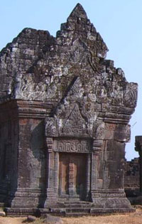
Wat Phou combines monumental Khmer stone architecture with a steep ceremonial ascent toward Phou Kao.
The Seven-Stage Ascent
The upper section rises through seven constructed stages with seven sets of eleven steps. Mature trees provide shade in parts of the ascent, but the exposed stone stairways become hot around midday and slippery during rain.
The climb is not a technical hike, but it is considerably more demanding than the relatively flat lower complex. Take your time, particularly in March and April heat.
The upper terrace rewards the climb with broad views across reservoirs, rice fields and the Mekong plain. More importantly, the higher level reveals why the sanctuary was placed directly beneath the sacred cliff and spring.
Main Sanctuary
The surviving sanctuary is primarily Baphuon style and dates to around the middle of the 11th century. Its front section is built from sandstone, while the rear cella was constructed in brick.
The cella originally sheltered a Shiva linga. The sanctuary exterior preserves carved guardians, devatas and apsaras, together with decorated lintels and pediments.
Look for depictions associated with:
- Krishna, an avatar of Vishnu;
- Indra;
- Vishnu;
- Shiva in ascetic form;
- scenes connected with the Ramayana;
- dvarapala guardian figures;
- devata and apsara figures.
The Sacred Spring and Wat Phou’s Unique Water System
The sacred spring is one of Wat Phou’s most important attributes and the key to understanding why the sanctuary stands here.
Water emerges from the cliff immediately behind the sanctuary. Archaeological work has identified basins, channels, aqueduct elements and other structures created to collect and control the spring.
During one phase of Hindu worship, spring water was conveyed through a green-sandstone system directly toward the rear cella and appears to have continuously bathed the Shiva linga. Water then exited through a stone conduit known as a somasutra.
Watering a linga was normal in Khmer Hindu ritual, but the permanent supply from a natural mountain spring makes the Wat Phou arrangement exceptional. The relationship can be understood as:
Phou Kao → sacred spring → aqueduct → Shiva linga → ritual water.
This hydraulic-religious system is more important to the meaning of Wat Phou than the popular description of the temple simply as “Khmer ruins on a hillside.”
Trimurti and Rock Carvings
Behind the sanctuary, a relief cut into the supporting rock depicts the Trimurti: Shiva at the center with Brahma and Vishnu.
Farther north are additional rock carvings, including an elephant, crocodile and two snakes. Some older accounts claim the crocodile carving was associated with human sacrifice. Current Wat Phou heritage information explicitly states that this interpretation has not been proven.
Travelers should therefore treat sacrifice stories as unverified tradition, not archaeological fact.
Wat Phou Museum
Visit the Wat Phou Museum if you want to understand what you are seeing outside. The museum stands near the site entrance and contains objects that cannot safely remain scattered across archaeological sites.
Its collections include sculptures, inscriptions, religious objects, architectural fragments and material recovered from Wat Phou, Hong Nang Sida, Tomo and other sites across the cultural landscape. The interpretive room also provides maps and panels that explain the relationship between the main temple, Ancient City, Mekong and associated monuments.
One especially important object is the Mukhalinga from Tomo Temple, a linga represented with a human face. Other museum material includes stone elements connected with sacred-water systems and linga recovered from Khan Mak Houk in the Mekong.
The museum building was constructed between 2001 and 2003 with Japanese support. Its size was deliberately limited to reduce disturbance to buried archaeology and preserve views across the World Heritage landscape.
Wat Phou Opening Hours, Tickets and Accessibility
As of September 2026, Wat Phou remains fully open after the site’s transfer back to direct Lao government management. Ticketing, central parking and the electric-cart shuttle are continuing normally.
| Visitor Information | Current Published Details |
|---|---|
| Main archaeological site | 08:00-17:00 daily |
| Museum | Tourism Champasak publishes 08:00-16:00; the Vat Phou heritage office currently publishes closing at 16:30 |
| Standard foreign admission | 50,000 kip |
| Standard Lao admission | 20,000 kip |
| Early access | 06:00-08:00 |
| Late access | 16:30-18:00 |
| Foreign early/late admission | 55,000 kip |
| Lao early/late admission | 25,000 kip |
| Electric shuttle | Included in admission |
| Ticket validity | Valid for the day |
| Free admission | Monks, children under 10 and disabled visitors according to current official information |
Because the two official local sites currently differ slightly on museum closing time, travelers arriving late should plan to enter the museum before 16:00 rather than depending on the extra half hour.
Early-Morning Strategy
Visitors entering at 06:00 face one unusual planning issue: the museum is not yet open. In this case, reverse the normal sequence.
Go directly to the upper complex first, enjoy cooler temperatures and softer morning light, then visit the museum after it opens at 08:00.
This can be particularly worthwhile for photographers and travelers staying in Champasak town.
Accessibility
The included electric cart reduces the amount of walking across the lower archaeological zone, but it does not make the entire site step-free.
The museum, entrance area and portions of the lower complex are the easiest sections for travelers with limited mobility. Reaching the main sanctuary requires climbing multiple stone stairways through the seven-stage ascent.
Older travelers and visitors with reduced mobility can still gain substantial value from the museum, barays, causeway and lower monumental area even if they decide not to climb to the sanctuary.
How Long to Spend at Wat Phou
| Visit Style | Recommended Time |
|---|---|
| Quick visit | About 1.5-2 hours |
| Typical first visit | About 2.5-3 hours including museum |
| History and archaeology focus | Half day |
| Wat Phou + Hong Nang Sida | Half day to full day |
| Wider cultural-landscape exploration | Full day or longer |
Best Time to Visit Wat Phou
November to February is the best overall period for Wat Phou. Southern Laos remains warm even in the cool season, but lower rainfall and reduced humidity make the stone stairways and exposed lower complex considerably more comfortable.
| Season | Conditions | Wat Phou Experience |
|---|---|---|
| Nov-Feb | Dryer and less humid | Best overall weather for climbing, archaeology and photography |
| Mar-Apr | Hottest period | Start early; heat exposure on stone terraces becomes the main issue |
| May-Jun | Rain increases and landscape turns greener | More atmospheric scenery, but more humidity |
| Jul-Sep | Wettest period | Lush Phou Kao and active water systems, but wet stairs require caution |
| Oct | Transition toward dry season | Green landscape with improving travel conditions |
Nearby Pakse has a tropical lowland climate, so the old recommendation to pack substantial warm clothing for Wat Phou is misleading. A light layer can be comfortable at dawn during the coolest months, but sun protection, water and breathable clothing are much more important.
The dry season in Laos provides the easiest conditions for the upper climb and archaeological trails. By contrast, the rainy season in Laos gives Champasak its greenest appearance and makes the relationship between Phou Kao, springs, rice fields and waterways much more visible.
During wet weather, the practical concern is slippery stone, heavy rainfall and occasional transport disruption rather than the older guidebook emphasis on leeches.
Best Time of Day
Early morning is the best choice for most travelers. Temperatures are lower, stone surfaces have not yet absorbed a full day of heat and the view over the Champasak plain is often softer.
Late afternoon can also be attractive, but travelers should watch the 18:00 extended-access closing time and avoid starting the upper climb too late.
How to Get to Wat Phou from Pakse and Champasak
Champasak town is the best local base for Wat Phou, while Pakse is the more convenient regional transport hub.
| Starting Point | Approximate Distance / Time | Best For |
|---|---|---|
| Champasak town | About 10 km | Early access, bicycles, motorbikes and slow travel |
| Pakse Airport to Champasak | About 45 km / around 45 min | Air arrivals |
| Central Pakse to Champasak | About 40 km / around 40 min by road | Day trips and onward southern-Laos travel |
| Pakse to Champasak by local slow boat | About 2 hrs when arranged | Travelers wanting a Mekong approach |
| Ubon Ratchathani via Chong Mek | About 160 km to Champasak / roughly 2.5 hrs under normal conditions | Thailand-Laos overland itineraries |
From Champasak Town
The 10-kilometer journey is straightforward by bicycle, motorbike, tuk-tuk or private vehicle. Cycling works best in the cooler morning hours and suits travelers who want to explore the rice-field landscape rather than simply transfer directly to the ticket gate.
From Pakse
Pakse works well if Wat Phou is one part of a broader southern Laos itinerary. Travelers can arrange taxis, vans, motorbikes or private transport. Families, older travelers and anyone combining several rural stops may find a car with driver in Laos more practical than coordinating multiple local transfers.
A local slow boat between Pakse and Champasak can also be arranged on request. The river journey takes around two hours and offers a very different introduction to the Champasak landscape, although departure arrangements should be confirmed through accommodation or the local tourism office.
From Thailand
Travelers entering southern Laos from Thailand commonly cross at Chong Mek and continue through Pakse or directly toward Champasak. Border opening times and Lao entry requirements can change, so verify them before an international road trip.
Wat Phou Festival
Wat Phou Festival is the most important time to see the site as a living Buddhist pilgrimage center rather than only an archaeological attraction.
The festival is linked to the Buddhist lunar calendar and is generally held around the full moon of the third lunar month. Exact Gregorian dates therefore change each year.
In 2026, the festival ran from January 31 to February 2 and marked the 25th anniversary of Wat Phou’s World Heritage inscription. Events included Buddhist worship, Dhamma teaching, overnight chanting, morning alms, cultural performances, a light-and-sound presentation and a candlelight procession associated with Makha Busa.
The opening celebration also included contemporary visual displays such as drones and fireworks. These large-scale elements vary from year to year and should not be treated as permanent festival features.
Older tourism pages sometimes repeat lists including animal fights or races as standard Wat Phou Festival attractions. Current 2026 reporting does not establish these as reliable recurring components, so travelers should check the year’s official program rather than relying on an old activity list.
Travelers planning a broader cultural trip can place the festival alongside other festivals in Laos, but should book Champasak accommodation well ahead when festival dates are confirmed.
Ancient City, Hong Nang Sida and the Khmer Road to Angkor
The biggest mistake a history-focused visitor can make is assuming the World Heritage experience ends at the Wat Phou ticketed temple complex. Some of the most important evidence for the site’s political and regional importance lies across the surrounding Champasak plain.
Ancient City, Often Identified with Shrestapura
The Ancient City covers roughly two by 1.8 kilometers and is enclosed by double earthen walls. Archaeological evidence places its foundation around the middle of the 5th century.
Do not expect a second Angkor Thom filled with standing towers. Much of the Ancient City survives as subtle archaeology: earth ramparts, ponds, mounds, fields and partially buried structures. Its urban organization is often clearer from archaeological mapping and aerial imagery than from ground level.
Important landscape elements include ancient reservoirs such as Nong Saphang Noi and Nong Saphang Yai, together with wall lines, religious remains and agricultural areas.
Hong Nang Sida
Hong Nang Sida is the most worthwhile archaeological extension for visitors who want more than the main Wat Phou complex.
The Khmer sanctuary lies along the ancient road south of Wat Phou and can be reached in roughly half an hour on foot from the wider monumental area. It was constructed around the early 12th century.
A major Lao-Korean conservation and restoration program ran from 2013 to 2025, with the restored site formally handed back to Laos on November 24, 2025. Current September 2026 government information specifically confirms that Hong Nang Sida remains accessible to visitors.
Its value comes not only from the restored structure but from its location on the old route extending south toward other Khmer foundations and, ultimately, the wider Angkor road network.
Thao Tao
Farther from the standard visitor circuit, Thao Tao is a smaller 13th-century complex associated with the reign of Jayavarman VII. Its layout is characteristic of the hospital chapels constructed across the Khmer Empire.
The ruins are more modest and access is less straightforward than Hong Nang Sida. It is therefore better suited to archaeology-focused travelers, ideally with current local guidance, than to a rushed first-time visit.
Tomo, Oub Moung or Oum Moung
Across the Mekong stands another related Khmer site commonly called Tomo Temple, Oub Moung or Oum Moung. The forested ruins preserve evidence from the broader Khmer religious landscape, including pre-Angkorian sculptural material.
A notable human-faced linga, or Mukhalinga, originally associated with Tomo is now protected in the Wat Phou Museum.
Tomo is less convenient than the core Wat Phou-Hong Nang Sida route and should be planned as a separate archaeological excursion rather than treated as a quick addition after the upper sanctuary.
Khan Mak Houk and the Sacred Mekong
One of the most unusual archaeological entities in the wider landscape is Khan Mak Houk, a group of rocks near the southern end of Don Daeng.
Archaeologists documented numerous small linga carved directly into the river rock, together with Vishnu-related imagery and other Hindu motifs. The intention appears to have been to sanctify the Mekong’s water, conceptually recalling carved riverbeds such as Kbal Spean in Cambodia.
Khan Mak Houk is highly seasonal. The carvings become accessible only when Mekong levels are sufficiently low and can be submerged by several meters during the rainy season. It should therefore be considered a specialist, locally arranged dry-season extension rather than a guaranteed attraction.
Vat Muang Kang and Wat Phou’s Living Buddhist Landscape
Champasak’s religious history did not end when Hindu worship declined. Active Buddhist monasteries across the cultural landscape show how later Lao religious life developed within and beside the older archaeological setting.
A striking recent example came from Vat Muang Kang, also called Vat Phuthavanaram. Restoration work on the monastery library led to the discovery in July 2025 of 69 small Buddha statuettes, along with heads and fragments.
The figures were made from a plant-resin core and covered with thin metal leaf. Several have inscriptions on their bases. The objects were transferred to Wat Phou Museum for documentation and conservation.
Vat Muang Kang itself is notable for architecture combining traditional Lao, Vietnamese and colonial influences. The monastery library once held a significant collection of palm-leaf manuscripts, and restoration work is intended to support the preservation and interpretation of that Buddhist heritage.
This creates an important historical relationship:
ancient Hindu landscape → Khmer sanctuary → Theravada Buddhism → living Champasak monasteries → contemporary archaeological conservation.
What Else to See Around Champasak
Champasak rewards travelers who give the cultural landscape at least one extra day instead of driving straight back to Pakse after Wat Phou.
Champasak Town
The riverside town lies about 10 kilometers from Wat Phou and contains Buddhist temples, wooden houses, colonial-period architecture, restaurants, cafes and small craft initiatives.
Current local cultural projects include shadow-puppet performances during the high season, traditional music activities, bamboo crafts and locally made ceremonial flower arrangements.
The town also provides bicycles, motorbike rental, ATMs, accommodation and tourism information, making it the most practical base for travelers who want early or late Wat Phou access.
Don Daeng Island
Don Daeng offers a contrasting experience of village paths, agricultural landscapes and Mekong scenery. It can be explored on foot, by bicycle or motorbike after a local boat crossing.
The island works especially well for couples, photographers and slow travelers who want to balance archaeological sightseeing with rural Champasak life.
Its southern end also lies within the wider archaeological context of Khan Mak Houk, although access to the carved river rocks depends on low-water conditions.
Champasak’s Thematic Trails
The Wat Phou heritage program has developed eight thematic trails combining archaeology, nature and local life. They include:
| Trail | Main Focus |
|---|---|
| Wat Phou – Hong Nang Sida – Thao Tao | Khmer archaeology, ancient road and nature |
| Wat Phou – Oub Moung – Tam Lek | Archaeology and natural landscape |
| Ancient City – Vat Louang Kao | Early settlement and archaeology |
| Tomo Temple | Cross-Mekong archaeology |
| Ancient City – Vat Muang Kang | Buddhist heritage and village life |
| Don Daeng Island | Mekong scenery and local life |
| Champasak town | Architecture, temples and living heritage |
| Rice-field route | Agriculture, rural landscape and village life |
Some extensions are seasonal or require a local guide, particularly where archaeological traces are difficult to locate independently.
Where to Stay: Pakse or Champasak?
Stay in Champasak if Wat Phou and the UNESCO landscape are a major focus of your trip. Stay in Pakse if Wat Phou is one stop within a broader southern Laos itinerary.
| Base | Best For | Main Advantage | Trade-Off |
|---|---|---|---|
| Champasak town | Wat Phou, archaeology, cycling and slow travel | Only about 10 km from the temple; easy 06:00 access | Fewer onward transport options than Pakse |
| Pakse | Flights, buses, Bolaven Plateau and multi-stop southern Laos | Main regional transport hub | Requires a separate transfer to Wat Phou |
Champasak accommodation ranges from family guesthouses to higher-end riverside properties. The town is the stronger choice for photographers who want to reach Wat Phou at opening time or travelers planning Hong Nang Sida and the thematic trails.
Pakse is more efficient for travelers connecting Wat Phou with the Bolaven Plateau or continuing farther south. It is better to treat those destinations as subsequent itinerary segments rather than trying to combine Wat Phou, distant waterfalls and Si Phan Don into one rushed sightseeing day.
Wat Phou Today: Conservation and Management in 2026
Wat Phou is an actively managed archaeological landscape, not a heritage site whose conservation ended after UNESCO inscription.
International conservation programs have involved Lao authorities alongside partners from countries including France, India, South Korea and Japan. Recent work has included archaeological research, LiDAR survey, monument restoration, museum development and studies of historic routes.
Hong Nang Sida’s long restoration program formally concluded in November 2025. Work and research across the wider property continue, including conservation of stone structures and interpretation of Champasak’s living historic landscape.
Management Change in September 2026
On September 1, 2026, the Lao government resumed direct management and conservation of the Wat Phou Champasak World Heritage Site after the previous private tourism concession expired.
The transition has not closed the site. Current government information confirms that:
ticketing, central parking, electric-cart services and visitor access are continuing, including access to Hong Nang Sida.
Authorities have also announced plans to improve cleanliness, landscaping, tourist information and visitor facilities. Because this management transition is very recent, admission fees and operational arrangements should be rechecked for trips planned well into 2027.
UNESCO and the Phou Ngoy Hydropower Proposal
UNESCO continues to monitor development proposals that could affect the wider Champasak cultural landscape. One issue under review is the proposed Phou Ngoy hydropower project.
The World Heritage Committee has requested heritage-impact assessment and consideration of alternatives because of possible impacts on the property’s Outstanding Universal Value.
This does not mean current Wat Phou visits are disrupted by the project. For travelers, it is conservation context rather than a current access warning.
Wat Phou Travel Tips
- Start early: the lower complex and stone stairs become hot once the sun is high.
- Use the museum strategically: visit it first during normal hours, but go directly to the sanctuary if using 06:00 early access.
- Carry water: drinks are available around the entrance and shuttle area, but bring water for the upper climb.
- Use sun protection: parts of the causeway, reservoirs and lower terraces have little shade.
- Wear shoes with grip: centuries-old stone steps become slippery during rain.
- Allow at least 2.5-3 hours: rushing straight to the sanctuary misses the museum and ceremonial sequence.
- Do not rely on “Men’s Palace” and “Women’s Palace” as historical facts: the functions of the two quadrangles remain uncertain.
- Treat sacrifice stories cautiously: heritage authorities say the human-sacrifice interpretation of the crocodile carving is unproven.
- Respect Buddhist worship: Wat Phou remains a pilgrimage site, so dress modestly and avoid obstructing people making offerings.
- Do not climb archaeological structures: use established stairs and visitor routes.
- Arrange remote sites locally: Tomo, Khan Mak Houk and some thematic-trail extensions are not standard independent sightseeing stops.
- Check official information close to travel: the September 2026 management transition could bring future changes to tickets or visitor services.
Visa, money, connectivity and general etiquette for the country are covered in the practical guide to traveling to Laos.
Wat Phou Travel FAQ
Is Wat Phou worth visiting?
Yes. Wat Phou is one of Laos’s most important archaeological sites and differs from a conventional ruined temple because its meaning depends on the relationship between Phou Kao, sacred water, Khmer architecture, ancient cities and the Mekong landscape.
Is Wat Phou older than Angkor Wat?
The sacred site and early sanctuary at Phou Kao existed centuries before Angkor Wat. However, much of the monumental Wat Phou complex visible today dates from the early to mid-11th century, while Angkor Wat was mainly constructed in the early 12th century. It is therefore more accurate to distinguish the site’s early religious history from the date of its surviving buildings.
How much is the Wat Phou entrance fee?
Current official information lists standard foreign admission at 50,000 kip and Lao admission at 20,000 kip. Electric-cart transport and museum admission are included. Early or late access currently costs 55,000 kip for foreign visitors.
What are Wat Phou’s opening hours?
The archaeological site currently opens from 08:00 to 17:00, with paid early access from 06:00 to 08:00 and late access from 16:30 to 18:00. Official local sources currently differ slightly on whether the museum closes at 16:00 or 16:30, so arrive before 16:00 for certainty.
How long should I spend at Wat Phou?
Allow around 2.5 to 3 hours for a good first visit including the museum and upper sanctuary. Archaeology enthusiasts should reserve a half day, while Wat Phou plus Hong Nang Sida can justify most of a day.
Is Wat Phou difficult to climb?
The lower complex is relatively easy and an electric shuttle is included, but the upper sanctuary requires climbing multiple historic stone stairways through seven stages. The climb is manageable for many visitors but can be tiring in hot weather and slippery after rain.
Can travelers with limited mobility visit Wat Phou?
Yes, but not all parts are accessible. The museum and lower complex provide a worthwhile visit, while the upper sanctuary is difficult for anyone unable to manage uneven stone stairs.
What is the best month to visit Wat Phou?
December and January are particularly comfortable, while November through February is the best broader period. February can also coincide with the annual Wat Phou Festival depending on the lunar calendar.
Should I stay in Pakse or Champasak?
Stay in Champasak if you want early Wat Phou access, archaeology, cycling and a slower Mekong atmosphere. Stay in Pakse if airport and bus connections, the Bolaven Plateau or a wider southern Laos itinerary matter more.
Can I visit Hong Nang Sida?
Yes. Current September 2026 government information confirms continued visitor access to Hong Nang Sida after completion of the major Lao-Korean restoration program in 2025.
Is Wat Phou still a religious site?
Yes. Although it began as a Hindu sanctuary centered on Shiva, Wat Phou later developed into a Theravada Buddhist pilgrimage site. Buddhist worship continues, especially during the annual Wat Phou Festival.
Is Wat Phou the only attraction in the UNESCO site?
No. The 39,000-hectare World Heritage property includes the main Wat Phou complex, Phou Kao, ancient settlements, archaeological sites, historic roads, water systems and a living Champasak cultural landscape. Hong Nang Sida and the Ancient City are the most useful extensions for first-time history-focused visitors.
Travelers building a longer cultural journey through the country can combine Champasak with other destinations through Laos tour, while keeping enough time to experience Wat Phou as a landscape rather than a quick photo stop.