Bagan Travel Guide

Bagan, formerly Pagan, formally titled Arimaddanapura and also known as Tambadipa or Tassadessa, was the ancient capital of several ancient kingdoms in Myanmar. It is located in the dry central plains of the country, on the eastern bank of the Ayeyarwady River, 145 kilometres southwest of Mandalay.
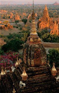
The site of an old capital city of Myanmar, Bagan is a pilgrimage centre and contains ancient Buddhist shrines that have been restored and redecorated and are in current use. Ruins of other shrines and pagodas cover a wide area. An earthquake on July 8, 1975, severely damaged more than half of the important structures and irreparably destroyed many of them. The whole of the Buphaya Pagoda, for nine centuries a landmark for river-boatmen, tumbled into the Ayeyarwaddy and was carried off by the waters. The village also has a school for lacquerware, for which the region is noted.
Bagan’s importance lies in its heritage rather than its present. It was first built probably in AD 849 and, from the 11th century to the end of the 13th, was the capital of a region roughly the size of modern Myanmar. In 1287 it was overrun by the Mongols during their wide-ranging conquests, and it never recovered its position, though a little desultory building continued on Buddhist shrines.
Among these pagodas, there are four most famous pagodas which has the special features as follows :
Old Bagan was a walled city, its western flank resting on the Ayeyarwaddy River. It was the focus of a network of high roads by means of which its rulers could command a large region of fertile plains and could dominate other major Myanmar dynastic cities, such as Pegu. From the port of Thiripyissaya, further down the river, important overseas trade was conducted with India, Ceylon, and other regions of Southeast Asia. The walls of the old city, within which lies a substantial area of the modern town, probably originally contained only royal, aristocratic, religious, and administrative buildings. The populace is thought to have lived outside in homes of light construction closely resembling those occupied by the present-day inhabitants.

The walled city, whose moats were fed by the Ayeyarwaddy , was thus a sacred dynastic fortress. The circuit of its walls and river frontage is some 4 km, and there is evidence that perhaps as much as a third of the old city has been washedaway by the river. Because building was principally in brick, decoration was carried out in carved brick, in stucco, and in terra-cotta. The earliest surviving structure is probably the 10th-century Nat Hlaung Gyaung. The shrines that stand by the Sarabha Gate in the eastern wall, although later than the wall they adjoin, are also early. These are shrines of protecting nats–the traditional spirit deities of the animist ethnic Burmans.
Between about 500 and 950, people of the Burman ethnic group had been infiltrating from the north into a region occupied by other peoples; these people already had been converted to Indian religion, especially the Mahayana Buddhism of Bihar and Bengal. Under King Anawrahta (reigned 1044-77), the ethnic Burmans finally conquered the other peoples of the region, including a people called the Mon, who were previously dominant in the south. They transported the Mon royal family and their scholars and craftsmen to Bagan, making it the capital and centre of an official, fundamentalist form of Hinayana (Theravada) Buddhism adopted from Ceylon (Sri Lanka), about 1056. This initiated the period of Bagan’s greatness, which was sustained at first by Mon artistic traditions. The enormous number of monasteries and shrines built and maintained during the next 200 years was made possible both by the great wealth of the royal exchequer and by the large number of slaves, skilled and unskilled, whose working lives were dedicated to the support of each institution. The city became one of the most important centres of Buddhist learning.

